Difference between revisions of "Hydrology"
Cellsworth (Talk | contribs) |
Cellsworth (Talk | contribs) |
||
| Line 3: | Line 3: | ||
[http://www.usbr.gov/uc/water/crsp/cs/gcd.html '''Current Status'''] | [http://www.usbr.gov/uc/water/crsp/cs/gcd.html '''Current Status'''] | ||
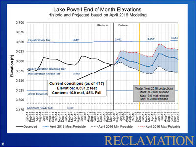
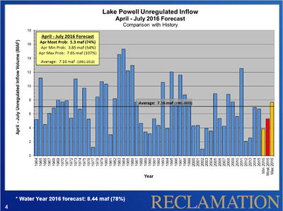
| − | The unregulated inflow volume to Lake Powell in | + | The unregulated inflow volume to Lake Powell in May was 2,294 thousand acre-feet (kaf) (98 percent of average). The release volume from Glen Canyon Dam in May was 700 kaf. The end of May elevation and storage of Lake Powell were 3,604 ft (96 feet from full pool) and 12.1 maf (50% of full capacity), respectively. The reservoir reached a seasonal low elevation on April 15th near elevation 3591.14 feet. Since that time the reservoir elevation has been increasing and will continue to increase throughout mid-summer as runoff from snowmelt and precipitation enter the reservoir. |
[http://www.usbr.gov/uc/water/crsp/cs/gcd.html '''Inflow Forecasts and Model Projections'''] | [http://www.usbr.gov/uc/water/crsp/cs/gcd.html '''Inflow Forecasts and Model Projections'''] | ||
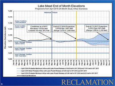
| − | The April | + | The operating tier for water year 2016 was established in August 2015 as the Upper Elevation Balancing Tier. The April 2016 24-Month Study established that Lake Powell operations will be governed by balancing for the remainder of water year 2016. Under balancing, the contents of Lake Powell and Lake Mead will be balanced by the end of the water year, but not more than 9.0 maf and not less than 8.23 maf shall be released from Lake Powell. Based on the most probable inflow forecast, this June 24-Month Study projects a balancing release of 9.0 maf in water year 2016; the actual release in water year 2016, however, will depend on hydrology in the remainder of water year and will range from 8.23 to 9.0 maf. The projected release from Lake Powell in water year 2016 will be updated each month throughout the remainder of the water year. Reclamation will schedule operations at Glen Canyon Dam to achieve as practicably as possible the appropriate total annual release volume by September 30, 2016. |
| − | + | In June, the release volume will be approximately 800 kaf, with fluctuations anticipated between about 9,000 cfs in the nighttime to about 17,000 cfs in the daytime and consistent with the Glen Canyon Operating Criteria (Federal Register, Volume 62, No. 41, March 3, 1997). The anticipated release volume for July is 950 kaf with daily fluctuations between approximately 11,500 cfs and 19,500 cfs. The expected release for August is 900 kaf with daily fluctuations between approximately 10,000 cfs and 18,000 cfs. | |
| − | |||
| − | |||
| − | |||
---- | ---- | ||
__NOTOC__ __NOEDITSECTION__ | __NOTOC__ __NOEDITSECTION__ | ||
| Line 66: | Line 63: | ||
| − | == USBR Weekly Water Report == | + | == '''USBR Weekly Water Report''' == |
| + | |||
* [http://www.usbr.gov/lc/region/g4000/weekly.pdf USBR Water Report] | * [http://www.usbr.gov/lc/region/g4000/weekly.pdf USBR Water Report] | ||
| − | * [http://www.usbr.gov/lc/region/g4000/hourly/forecast09.pdf | + | * [http://www.usbr.gov/lc/region/g4000/hourly/forecast09.pdf USBR -LC Region Hourly Forecasts] |
| − | * [http://www.usbr.gov/lc/region/g4000/wtracct.html USBR- Historic Use Records | + | * [http://www.usbr.gov/lc/region/g4000/wtracct.html USBR- Historic Use Records Water Accounting Reports'''] |
---- | ---- | ||
| − | == Snow Pack Reports == | + | == '''Snow Pack Reports''' == |
| − | *[http://www.usbr.gov/uc/water/notice/snowpack.html Bureau of Reclamation- | + | *[http://www.usbr.gov/uc/water/notice/snowpack.html Bureau of Reclamation- Snow Pack Report] |
| − | *[http://www.cbrfc.noaa.gov/snow/station/sweplot/sweplot.cgi?quick=multiple | + | *[http://www.cbrfc.noaa.gov/snow/station/sweplot/sweplot.cgi?quick=multiple SNOWTEL Report] |
| − | **The | + | **The snowtel report is a calculating report, and takes approximately 3 minutes to run. |
| − | **Select the report under "Public", listed as "Colorado River above Lake Powell" (116 | + | **Select the report under "Public", listed as "Colorado River above Lake Powell" (116 snowtel sites). |
| − | **Data source is | + | **Data source is updated at least daily. |
---- | ---- | ||
| − | == U.S. Drought Monitor == | + | == '''U.S. Drought Monitor''' == |
| − | * [http://drought.unl.edu/DM/MONITOR.HTML | + | *[http://drought.unl.edu/DM/MONITOR.HTML U.S. Drought Monitor] |
| − | *[http://treeflow.info/basin.html | + | *[http://treeflow.info/basin.html Tree Flow Data] |
---- | ---- | ||
| Line 103: | Line 101: | ||
|- | |- | ||
|style="color:#000;"| | |style="color:#000;"| | ||
| − | *[http://graphs.water-data.com/lakepowell/ | + | *[http://graphs.water-data.com/lakepowell/ Lake Powell Water Level Graphs] |
| − | *[http://www.gcmrc.gov/discharge_qw_sediment/station/GCDAMP/09380000 | + | *[http://www.gcmrc.gov/discharge_qw_sediment/station/GCDAMP/09380000 Colorado River at Lees Ferry] |
| − | *[http://waterdata.usgs.gov/az/nwis/uv?site_no=09382000 | + | *[http://waterdata.usgs.gov/az/nwis/uv?site_no=09382000 Paria River at Lees Ferry] |
| − | *[http://www.gcmrc.gov/discharge_qw_sediment/station/GCDAMP/09383050 | + | *[http://www.gcmrc.gov/discharge_qw_sediment/station/GCDAMP/09383050 Colorado River at 30 mile] |
| − | *[http://www.gcmrc.gov/discharge_qw_sediment/station/GCDAMP/09383100 | + | *[http://www.gcmrc.gov/discharge_qw_sediment/station/GCDAMP/09383100 Colorado River above LCR] |
| − | *[http://waterdata.usgs.gov/az/nwis/uv?site_no=09402300 | + | *[http://waterdata.usgs.gov/az/nwis/uv?site_no=09402300 LCR at Colorado River] |
| − | *[http://waterdata.usgs.gov/az/nwis/uv?site_no=09402500 | + | *[http://waterdata.usgs.gov/az/nwis/uv?site_no=09402500 Colorado River at Bright Angel Creek] |
| − | *[http://www.gcmrc.gov/discharge_qw_sediment/station/GCDAMP/09403000 | + | *[http://www.gcmrc.gov/discharge_qw_sediment/station/GCDAMP/09403000 Bright Angel Creek] |
| − | *[http://www.gcmrc.gov/discharge_qw_sediment/station/GCDAMP/GCMRC-MCLT6 | + | *[http://www.gcmrc.gov/discharge_qw_sediment/station/GCDAMP/GCMRC-MCLT6 Shinumo Creek] |
| − | *[http://www.gcmrc.gov/discharge_qw_sediment/station/GCDAMP/09402352 | + | *[http://www.gcmrc.gov/discharge_qw_sediment/station/GCDAMP/09402352 Colorado River abv Lava Canyon rm66] |
| − | *[http://www.gcmrc.gov/discharge_qw_sediment/station/GCDAMP/09403270 | + | *[http://www.gcmrc.gov/discharge_qw_sediment/station/GCDAMP/09403270 Colorado River bl rm127] |
| − | *[http://www.gcmrc.gov/discharge_qw_sediment/station/GCDAMP/09403850 | + | *[http://www.gcmrc.gov/discharge_qw_sediment/station/GCDAMP/09403850 Kanab Creek] |
| − | *[http://www.gcmrc.gov/discharge_qw_sediment/station/GCDAMP/09404115 | + | *[http://www.gcmrc.gov/discharge_qw_sediment/station/GCDAMP/09404115 Havasu Creek] |
| − | *[http://www.gcmrc.gov/discharge_qw_sediment/station/GCDAMP/09404120 | + | *[http://www.gcmrc.gov/discharge_qw_sediment/station/GCDAMP/09404120 Colorado River abv National Canyon] |
| − | *[http://www.gcmrc.gov/discharge_qw_sediment/station/GCDAMP/09404200 | + | *[http://www.gcmrc.gov/discharge_qw_sediment/station/GCDAMP/09404200 Colorado River bl Diamond Creek] |
| − | *[http://www.gcmrc.gov/discharge_qw_sediment/station/GCDAMP/09404220 '''Colorado River abv Spencer rm246 | + | *[http://www.gcmrc.gov/discharge_qw_sediment/station/GCDAMP/09404220 '''Colorado River abv Spencer rm246] |
| − | *[http://graphs.water-data.com/lakemead/ | + | *[http://graphs.water-data.com/lakemead/ Lake Mead Water Level Graphs] |
| Line 128: | Line 126: | ||
|style="color:#000;"| | |style="color:#000;"| | ||
| − | 2016 | + | '''2016''' |
*[[Media:2017 Hydrology PPT.pdf| TWG: Basin Hydrology, Operations, and 2017 Hydrograph]] | *[[Media:2017 Hydrology PPT.pdf| TWG: Basin Hydrology, Operations, and 2017 Hydrograph]] | ||
*[http://www.usbr.gov/uc/rm/amp/amwg/mtgs/16feb24/pdf/Attach_08.pdf AMWG: Basin Hydrology, Operations, and 2017 Hydrograph] | *[http://www.usbr.gov/uc/rm/amp/amwg/mtgs/16feb24/pdf/Attach_08.pdf AMWG: Basin Hydrology, Operations, and 2017 Hydrograph] | ||
*[http://www.usbr.gov/uc/rm/amp/twg/mtgs/16jan26/documents/Attach_02.pdf Glen Canyon Dam Operations During Equalization] | *[http://www.usbr.gov/uc/rm/amp/twg/mtgs/16jan26/documents/Attach_02.pdf Glen Canyon Dam Operations During Equalization] | ||
| − | 2015 | + | '''2015''' |
*[https://drive.google.com/file/d/0BwY-Z2c3NTUGTU41NkhzUi1ZTTg/view California Drought Monitor] | *[https://drive.google.com/file/d/0BwY-Z2c3NTUGTU41NkhzUi1ZTTg/view California Drought Monitor] | ||
*[https://drive.google.com/file/d/0BwY-Z2c3NTUGOVVVUXFhZVBvNmM/view Lake Mead Issues and Lower Basin Shortage Preparedness] | *[https://drive.google.com/file/d/0BwY-Z2c3NTUGOVVVUXFhZVBvNmM/view Lake Mead Issues and Lower Basin Shortage Preparedness] | ||
| Line 146: | Line 144: | ||
*[http://www.usbr.gov/uc/rm/amp/twg/mtgs/15apr21/Attach_03.pdf Hydrology Update and 2016 Hydrograph] | *[http://www.usbr.gov/uc/rm/amp/twg/mtgs/15apr21/Attach_03.pdf Hydrology Update and 2016 Hydrograph] | ||
| − | 2014 | + | '''2014''' |
Revision as of 16:32, 24 June 2016
The unregulated inflow volume to Lake Powell in May was 2,294 thousand acre-feet (kaf) (98 percent of average). The release volume from Glen Canyon Dam in May was 700 kaf. The end of May elevation and storage of Lake Powell were 3,604 ft (96 feet from full pool) and 12.1 maf (50% of full capacity), respectively. The reservoir reached a seasonal low elevation on April 15th near elevation 3591.14 feet. Since that time the reservoir elevation has been increasing and will continue to increase throughout mid-summer as runoff from snowmelt and precipitation enter the reservoir.
Inflow Forecasts and Model Projections
The operating tier for water year 2016 was established in August 2015 as the Upper Elevation Balancing Tier. The April 2016 24-Month Study established that Lake Powell operations will be governed by balancing for the remainder of water year 2016. Under balancing, the contents of Lake Powell and Lake Mead will be balanced by the end of the water year, but not more than 9.0 maf and not less than 8.23 maf shall be released from Lake Powell. Based on the most probable inflow forecast, this June 24-Month Study projects a balancing release of 9.0 maf in water year 2016; the actual release in water year 2016, however, will depend on hydrology in the remainder of water year and will range from 8.23 to 9.0 maf. The projected release from Lake Powell in water year 2016 will be updated each month throughout the remainder of the water year. Reclamation will schedule operations at Glen Canyon Dam to achieve as practicably as possible the appropriate total annual release volume by September 30, 2016.
In June, the release volume will be approximately 800 kaf, with fluctuations anticipated between about 9,000 cfs in the nighttime to about 17,000 cfs in the daytime and consistent with the Glen Canyon Operating Criteria (Federal Register, Volume 62, No. 41, March 3, 1997). The anticipated release volume for July is 950 kaf with daily fluctuations between approximately 11,500 cfs and 19,500 cfs. The expected release for August is 900 kaf with daily fluctuations between approximately 10,000 cfs and 18,000 cfs.
|
|
| Table- Hydrology of the Colorado River |
--- | --- |
|---|
|
|


