Difference between revisions of "The 1965 Reservoir Equalization and Channel Cleaning Floods"
Cellsworth (Talk | contribs) (Created page with " __NOTOC__ __NOEDITSECTION__ <!-- ------------------------------Banner across top of page------------------------------> {| style="width:100%; background:#fcfcfc; margin-to...") |
Cellsworth (Talk | contribs) |
||
| (One intermediate revision by the same user not shown) | |||
| Line 40: | Line 40: | ||
|style="color:#000;"| | |style="color:#000;"| | ||
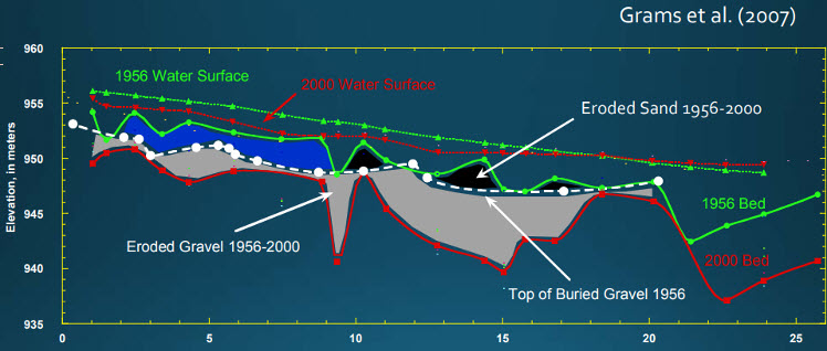
| − | + | The 1965 floods were designed to raise the elevation of | |
| + | Lake Mead reservoir and to scour the reach immediately | ||
| + | below Glen Canyon Dam in order to increase the efficiency | ||
| + | of the power plant at the dam, and were referred to informally by Bureau of | ||
| + | Reclamation engineers as "channel cleaning flows" | ||
| + | (Grams and others, Utah State University, written | ||
| + | commun., 2002). During these 3 months of high | ||
| + | discharge, approximately 5.0 million tons of fine sediment | ||
| + | (that is, sand and finer material) were scoured from Glen | ||
| + | Canyon between the dam and Lees Ferry (computed on | ||
| + | the basis of the USGS daily suspended-sediment data | ||
| + | from the Lees Ferry gaging station; U.S. Geological | ||
| + | Survey, accessed November 15, 2000), and approximately | ||
| + | 17.6 million tons of fine sediment were scoured from the | ||
| + | reach between the Lees Ferry and Grand Canyon gaging | ||
| + | stations (Rubin and Topping, 2001). Pages 46-47 [https://pubs.usgs.gov/pp/pp1677/pdf/pp1677.pdf ] | ||
| − | + | [[File:1956BedElevation.jpg]] [https://www.yumaheritage.com/docs/2nd-A-1JackSchmidt_USU_LoganUT.pdf] | |
<!-- | <!-- | ||
| Line 66: | Line 81: | ||
|style="color:#000;"| | |style="color:#000;"| | ||
| + | *[https://www.yumaheritage.com/docs/2nd-A-1JackSchmidt_USU_LoganUT.pdf Unintended (and intended) consequences... Urban Waterfronts 2018] | ||
| + | *[https://pubs.usgs.gov/pp/pp1677/pdf/pp1677.pdf Topping et al. 2003. Computation and analysis of the instantaneous-discharge record for the Colorado River at Lees Ferry, Arizona, May 8, 1921 through September 30, 2000: U.S. Geological Survey Professional Paper 1677, 118 p. ] | ||
|- | |- | ||
Latest revision as of 09:23, 29 June 2018
|
|
|
| -- |
-- |
-- |
|---|
|
