Difference between revisions of "TEMPERATURE"
Cellsworth (Talk | contribs) |
Cellsworth (Talk | contribs) |
||
| (6 intermediate revisions by the same user not shown) | |||
| Line 105: | Line 105: | ||
|style="color:#000;"| | |style="color:#000;"| | ||
| − | *[https://www.gcmrc.gov/discharge_qw_sediment/station/GCDAMP/09379901 Glen Canyon Dam near Page, AZ] | + | *[https://tableau.usgs.gov/views/colorado-river-water-quality-gcd/GlenCanyonDamSiteHourlyAverages?%3Aembed=y&%3AisGuestRedirectFromVizportal=y Glen Canyon Dam Site: Hourly Averages] |
| − | *[https://www.gcmrc.gov/discharge_qw_sediment/station/GCDAMP/09382000 Paria River at Lees Ferry, AZ] | + | *[https://www.gcmrc.gov/discharge_qw_sediment/station/GCDAMP/09379901 Glen Canyon Dam near Page, AZ (-15.62)] |
| − | *[http://www.gcmrc.gov/discharge_qw_sediment/station/GCDAMP/09380000 Colorado River at Lees Ferry] | + | *[https://www.gcmrc.gov/discharge_qw_sediment/station/GCDAMP/09382000 Paria River at Lees Ferry, AZ (0)] |
| + | *[http://www.gcmrc.gov/discharge_qw_sediment/station/GCDAMP/09380000 Colorado River at Lees Ferry (0)] | ||
*[http://www.gcmrc.gov/discharge_qw_sediment/station/GCDAMP/09383050 Colorado River near river mile 30] | *[http://www.gcmrc.gov/discharge_qw_sediment/station/GCDAMP/09383050 Colorado River near river mile 30] | ||
| − | *[http://www.gcmrc.gov/discharge_qw_sediment/station/GCDAMP/09383100 Colorado River above Little Colorado River near Desert View, AZ] | + | *[http://www.gcmrc.gov/discharge_qw_sediment/station/GCDAMP/09383100 Colorado River above Little Colorado River near Desert View, AZ (61)] |
| − | *[https://www.gcmrc.gov/discharge_qw_sediment/station/GCDAMP/09402300 Little Colorado River above the mouth near Desert View, AZ] | + | *[https://www.gcmrc.gov/discharge_qw_sediment/station/GCDAMP/09402300 Little Colorado River above the mouth near Desert View, AZ (61)] |
| − | *[ | + | *[http://www.gcmrc.gov/discharge_qw_sediment/station/GCDAMP/09402352 Colorado River abv Lava Canyon (66)] |
| − | *[ | + | *[https://www.gcmrc.gov/discharge_qw_sediment/station/GCDAMP/09402500 Colorado River near Grand Canyon, AZ (88)] |
| − | *[http://www.gcmrc.gov/discharge_qw_sediment/station/GCDAMP/ | + | *[http://www.gcmrc.gov/discharge_qw_sediment/station/GCDAMP/09403000 Bright Angel Creek near Grand Canyon, AZ (88)] |
| − | *[http://www.gcmrc.gov/discharge_qw_sediment/station/GCDAMP/09403270 Colorado River | + | *[http://www.gcmrc.gov/discharge_qw_sediment/station/GCDAMP/09403270 Colorado River below river mile 127] |
| − | *[http://www.gcmrc.gov/discharge_qw_sediment/station/GCDAMP/09403850 Kanab Creek above the mouth near Supai, AZ] | + | *[http://www.gcmrc.gov/discharge_qw_sediment/station/GCDAMP/09403850 Kanab Creek above the mouth near Supai, AZ (144)] |
| − | *[http://www.gcmrc.gov/discharge_qw_sediment/station/GCDAMP/09404115 Havasu Creek above the mouth near Supai, AZ] | + | *[http://www.gcmrc.gov/discharge_qw_sediment/station/GCDAMP/09404115 Havasu Creek above the mouth near Supai, AZ (157)] |
| − | *[http://www.gcmrc.gov/discharge_qw_sediment/station/GCDAMP/09404120 Colorado River above National Canyon near Supai, AZ] | + | *[http://www.gcmrc.gov/discharge_qw_sediment/station/GCDAMP/09404120 Colorado River above National Canyon near Supai, AZ (167)] |
| − | *[http://www.gcmrc.gov/discharge_qw_sediment/station/GCDAMP/09404200 Colorado River above Diamond Creek near Peach Springs, AZ] | + | *[http://www.gcmrc.gov/discharge_qw_sediment/station/GCDAMP/09404200 Colorado River above Diamond Creek near Peach Springs, AZ (225)] |
| − | *[http://www.gcmrc.gov/discharge_qw_sediment/station/GCDAMP/09404220 Colorado River above Spencer Creek | + | *[http://www.gcmrc.gov/discharge_qw_sediment/station/GCDAMP/09404220 Colorado River above Spencer Creek (246)] |
|- | |- | ||
| Line 125: | Line 126: | ||
|- | |- | ||
|style="color:#000;"| | |style="color:#000;"| | ||
| + | |||
| + | '''2022''' | ||
| + | *[https://www.paysonroundup.com/news/arizona_state/low-water-levels-at-lake-powell-impact-the-fish-downstream/article_9cff5e91-04e0-5147-9a3d-8eccbbb496b5.html?utm_medium=social&utm_source=email&utm_campaign=user-share Low water levels at Lake Powell impact the fish downstream] | ||
| + | *[https://www.usbr.gov/uc/progact/amp/amwg/2022-02-10-amwg-meeting/20220210-FY2022DroughtFundingInfrastructureAlternatives-508-UCRO.pdf FY 2022 Drought Funding: Infrastructure Alternatives ] | ||
| + | *[https://www.usbr.gov/uc/progact/amp/twg/2022-01-13-twg-meeting/20220113-TWGMeeting-BasinHydrologyOperationsWaterQuality-508-UCRO.pdf Basin Hydrology, Operations and Water Quality ] | ||
'''2021''' | '''2021''' | ||
Latest revision as of 12:54, 27 August 2024
|
|
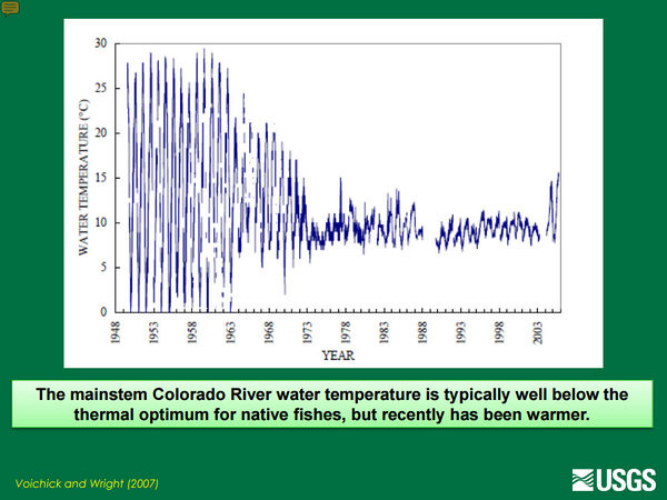
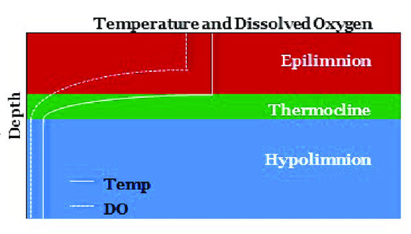
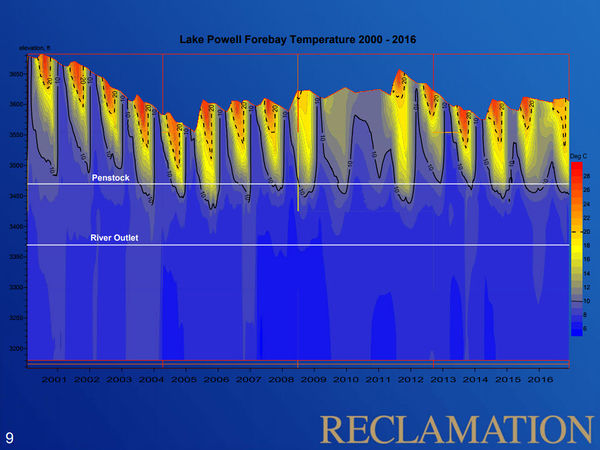
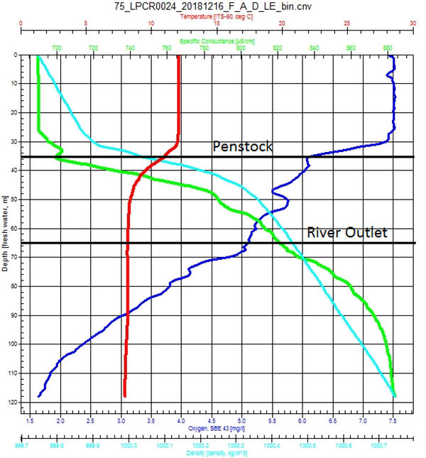
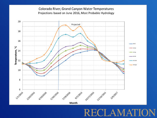
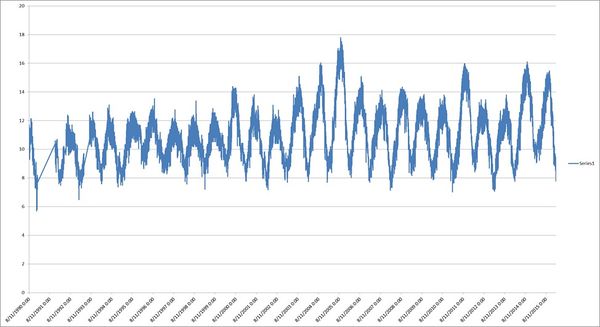
Water Temperature below Glen Canyon DamPrior to completion of Glen Canyon Dam in 1963, the temperature of water flowing through the Grand Canyon each year was highly variable, ranging from the icy, spring run-off to the warm, 85-degree summer-heated flows. However, once the dam was constructed, the temperature of the water released from the dam - drawn from the depths of Lake Powell and released through the dam's penstock intakes - ranged for many years between 45 and 50 F (7 to 10 C). With the lowering of Lake Powell, release temperatures have been increased to as high as 59 F (15 C) which has likely led to an increase in the humpback chub and other native fish populations in Grand Canyon. These increases in temperature, however, also increase the risk of expanding the distribution and abundance of cool/warm-water nonnative fish like brown trout, green sunfish, smallmouth bass, and walleye which could have a devastating impact on the humpback chub population in Grand Canyon like they have on humpback chub and other native fish populations in the Upper Basin. |
| --- |
--- |
--- |
|---|
