|
To test both spring and fall HFEs, the HFE protocol proposed using two sediment accounting periods.
These sediment accounting periods are used to track the quantity of new Paria River sand available for
building beaches in Marble Canyon during an HFE, and HFEs are only triggered if the quantity of new
sand is large. This sediment accounting approach to triggering HFEs, coupled with state-of-the-art
sediment monitoring (Topping and Wright 2016), eliminates the possibility of unintentionally scouring
sediment resources from Marble Canyon during HFEs. When the HFE protocol was first proposed, it was
estimated that sediment-triggered fall HFEs would occur approximately two out of every three years and
sediment-triggered spring HFEs would occur approximately once every three years (Wright and Kennedy
2011). [1]
Although Sediment-Triggered Spring HFEs and Proactive Spring HFEs are now possible, analysis of Paria
River discharge data indicates that Sediment-Triggered Spring HFEs may occur less frequently than
originally estimated (Grams and Topping 2018). Sediment accounting data available since the HFE
protocol was operationalized in 2012 bear this out. Specifically, since 2012 the sediment trigger for a fall
HFE has been reached 6 times (i.e., 2012-2016, 2018; no HFE occurred in 2015 owing to green sunfish)
while the sediment trigger for a spring HFE has never been reached (Grams and Topping 2020). Testing
of 5 fall HFEs over the past 8 years has benefitted sediment resources and reduced uncertainties
concerning sandbar response to HFEs in general (Figure 2). However, regular testing of fall HFEs since
2012 is also correlated with a growing population of brown trout in Lees Ferry (Runge and others 2018)
and critical uncertainties concerning the role of spring HFEs in achieving biological resource objectives
remain unanswered (Figure 2).
By May 2020, the FLAHG and GCMRC completed design of a conceptual hydrograph that included a high
spring release that was within power plant capacity. The FLAHG hydrograph capitalizes on a unique low
flow of 4,000 ft3 /s for 5 days, which is needed to conduct maintenance on the apron of Glen Canyon
Dam (see Figure 3). The FLAHG hydrograph proposes to follow this low flow disturbance with a high flow
disturbance that will culminate in a discharge of up to 25,000 ft3 /s for 82 hours. This combination of
desiccation at low flows followed by scour at high flows is hypothesized to disturb benthic habitats to a
much greater extent than either the low or high flows alone (Kennedy and others 2020). [2]
Below we present predicted effects of the FLAHG hydrograph on the 11 LTEMP Resource Goals using the
Knowledge Assessment rubric from 2019
(http://gcdamp.com/index.php?title=Portal:GCDAMP_Knowlege_Assessments). For comparison, and to
anchor predictions concerning the FLAHG hydrograph, we also used the Knowledge Assessment
framework to predict effects of Spring and Fall HFEs on LTEMP Resource Goals. To simplify analysis of
hydrograph impacts, the FLAHG narrowed consideration of testing this hydrograph to sometime in
March based on the following two main reasons: 1) both the 1996 and 2008 Spring HFEs also occurred in
March, which will simplify evaluation and comparison of new biological data that might be collected
around a FLAHG hydrograph to earlier data from those spring HFEs, and 2) a March test of the FLAHG
hydrograph will minimize adverse impacts of the low flow to Recreational Experience by avoiding the
start of the commercial river trip motor season in April.
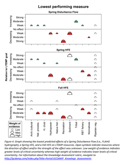
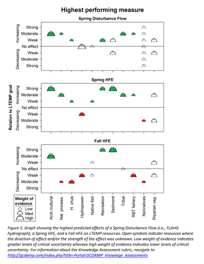
Knowledge Assessment groups often evaluated multiple specific measures to capture all the facets of a
given LTEMP goal. For example, the goal for Rainbow Trout Fishery is, “Achieve a healthy high-quality
recreational rainbow trout fishery in GCNRA and reduce or eliminate downstream trout migration
consistent with NPS fish management and ESA compliance.” To capture both facets of this goal, the
Knowledge Assessment team considered two specific measures: rainbow trout abundance in Lees Ferry,
and rainbow trout abundance at the Little Colorado River confluence. The predicted resource responses
to a given action often varied, depending on which specific measure was considered. We capture this
variation in predictions by presenting bookend, “lowest performing” and “highest performing”,
scenarios gleaned from the assessments and their differing specific measures. Note that the assessment
summaries and graphs are based on detailed assessments for each resource that were performed by
multiple subject matter experts (see section V. Acknowledgements for a complete list of participants).
Those detailed assessments are contained in a spreadsheet for each resource that accompany this
document. The detailed resource assessments were based on consideration of peer-reviewed literature,
modelling, and other quantitative science as well as more qualitative expert opinions, similar to previous
Knowledge Assessments. [3]
 |
Project Element O.1. Does Disturbance Timing Affect Food Base Response?
This element includes funding for tracking food base response to the FLAHG/GCRMC
hydrograph in Year 1 (Figure 1). Due to logistical constraints, we will focus our sampling efforts
in and around Lees Ferry. Specifically, we propose to sample aquatic insect drift intensively at
four time periods: just prior to the low flow associated with apron repair, during the low flow,
during the subsequent high flows after apron repair, and during the base flows immediately after
the high flow. Sampling would occur over the course of 1-2 weeks at 5-10 sites throughout Glen
Canyon and Upper Marble Canyon. Sites will be identical to our regular monitoring sites spaced
roughly equidistant from GCD (starting at River Mile [RM] -15) to the head of Badger Rapid
(RM 8), allowing us to contrast food web impacts above and below the Paria River confluence.
The objectives of this sampling are twofold:
- Quantify invertebrate export resulting from spring flow disturbance. Specifically, quantify the extent to which nonnative New Zealand mud snails are exported or suffer high mortality as a result of these flows, and the extent to which patterns of midge, blackfly, and Gammarus drift differ from baseline conditions in past spring seasons and during prior, fall HFEs.
- Quantify organic matter export resulting from drying during apron repair and subsequent flushing during high flows, which may have concomitant impacts on aquatic insect habitat and food resources.
Project Element O.2. Bank Erosion, Bed Sedimentation, and Channel Change in Western Grand Canyon
In order to address the above research questions, we intend to study channel response to dam
operations in a short (~1 to 3 km) study reach (to be selected) downstream from Quartermaster
Canyon. We will work with the Hualapai Tribe to select a specific reach that is critical for boat
navigation. In the first part of our analysis, we propose to use available remote sensing data sets
to document historical changes in bank and river channel morphology. The second part of the
analysis will include collection of repeat surveys of the riverbed within the selected study reach
before, during, and following a dam-released flow pulse. The repeat surveys will allow
quantification of the magnitude and spatial distribution of channel morphological change
associated with the flow pulse and the return to normal dam operations. This analysis will be
conducted by using the field data to develop a streamflow and sediment transport model for the
study reach. The model will allow evaluating bed response in a predictive framework to
determine whether there are systematic changes in bed elevation caused by dam operations.
Because similar issues exist upstream along the deltas of the Colorado and San Juan arms of
Lake Powell, this research project also could provide guidance for management of other large
reservoirs in the Colorado River Basin.
Project Element O.3. Aeolian Response to a Spring Pulse Flow
We
propose to conduct research during the FLAHG spring flow at a combined archaeological
dunefield-sand bar monitoring site from Project D.1 where NPS is also considering conducting
riparian vegetation removal through the LTEMP vegetation management project, which could
increase the aeolian transport of sand from the sandbar to adjacent archaeological site. We
propose to leverage the FLAHG flow to measure sand drying rates, change in exposed subaerial
sand, and aeolian sediment transport potential during the extended low flow of 4,000 ft3/s
and subsequent high flow at the study site.
Project Element O.4. Riparian Vegetation Physiological Response
We propose to select a subset of species from those listed in Project C.2 (Figure 5), depending on
availability of those species at accessible river sites. The species selected will represent both
flood tolerant and drought tolerant species and will likely include arrowweed (Pluchea sericea),
coyote willow (Salix exigua), Emory’s baccharis (Baccharis emoryi), tamarisk (Tamarix spp.),
Emory’s sedge (Carex emoryi), and available Juncus spp. The daily measurements will include
those of the mesocosm experiments: stomatal conductance, stem water potential, relative
humidity, leaf turgor, and soil moisture. Measurements will be collected daily starting two days
prior to the experimental flows through two days after.
The target location for this work will be in and around Lees Ferry. If, however, weather
conditions result in a late start to the spring growing season and the target species are unlikely to
be fully leafed out and active at the time of the FLAHG flows, we will relocate to the area near
Phantom Ranch. Plants will be active in that river segment during the FLAHG flows but are less
desirable simply due to logistics.
Project Element O.5. Mapping Aquatic Vegetation Response to a Spring Pulse Flow
We propose to use this unique opportunity (coupled with advances in Project Element E.2 in
TWP FY2021-23) to understand how a spring disturbance flow affects the dominant primary
producers in Glen Canyon, with a secondary objective of determining the scale at which we
might be able to do so. This would be designed as a before and after-impact study, with one trip
immediately prior to the low flow (e.g., late February or early March), one trip immediately after
the higher flow (e.g., late March or early April), and one trip in June to detect vegetation
response and recovery. Images from the June trip will be compared to baseline images from 2016
and 2019 that were taken in years lacking a spring disturbance flow. If we can detect a change in
aquatic vegetation cover and/or composition on a short-term scale (i.e., one season), then that
result will inform the frequency at which we should undergo aquatic vegetation surveys (Project
Element E.2). For example, if we can detect change within a season over multiple trips, this
method could be considered a sensitive tool for detecting vegetation community responses to
dam operations and would further our understanding of factors that drive primary production in
Glen Canyon (Project E).
Project Element O.6. Brown Trout Early Life Stage Response to a Spring Pulse Flow
While a low steady flow timed during peak emergence could improve short-term swim-up and
growth conditions for brown trout fry, we anticipate an energetic cost for newly emerged brown
trout fry during the spring disturbance flow. Therefore, we plan on collecting data during the
year of the spring disturbance flow and comparing results to a non-flow year using the methods
outlined in Project Element H.3, which will improve understanding of how spring flow
configurations may affect brown trout in their early life history stages. Results will be compared
to age-1 brown trout catch from the TRGD project in fall of Year 2 for comparison, which would
be an indicator of brown trout recruitment strength following the spring disturbance flow
(Project Element H.2).
Project Element O.7. Native Fish Movement in Response to a Spring Pulse Flow
We propose the use of sonic tags to track the responses of humpback
chub and flannelmouth sucker to the proposed spring disturbance flow. While rare, adult
razorback sucker will be included in this study if captured or detected on the remote Submersible
Ultrasonic Receiver (SUR) network, since the species also spawns in spring and may respond to
simulated flood hydrograph (USFWS, 2018). We propose targeting two study sites, one within
the JCM-west reach to economically align with ongoing studies (Project Elements G.5, G.6), and
one in the Lake Mead formation area below ~RM 235 that is accessible via up-runs from Pearce
Ferry. We propose to sonic tag approximately 35 adult fish per site, and USFWS will sonic tag
another 35 fish as a match, for a total of ~70. Approximately half the tags will be inserted into
adult flannelmouth sucker, the other half into humpback chub. If we capture any adult razorback
sucker, they will receive priority over the other two species since they are rare in the system. The
effort will benefit from an array of ~27 remote SURs already in place within Grand Canyon
distributed from the LCR to Pearce Ferry to passively track native fish movement. We will also
actively track fish at both sites as time and resources allow, combined with analysis of general
movement patterns at the JCM-west vs. JCM-east sites to refine mark-recapture modeling
(Project Elements G.3, G.6).
Project Element O.8. Do Disturbance Flows Significantly Impact Recreational Experience?
Surveys will be conducted to obtain information on recreationists’ preferences and economic
values associated with flow attributes specific to a spring disturbance flow experiment.
Consistent with past research of angler and whitewater boater’s flow preferences, the surveys
will be designed to elicit economic values using choice experiment instruments in addition to
investigation into other quantitative and qualitative metrics of recreationists’ preferences and
perspectives. Participants will be intercepted immediately prior, during, and following the spring
disturbance flow, differing from past recreational surveys (Bishop and others, 1987; Neher and
others, 2017), and respondents will either be interviewed on-site or sent a mail survey packet,
with a follow-up protocol for non-responders.
Project Element O.9. Are There Opportunities to Meet Hydropower and Energy Goals with Spring Disturbance Flows? (funded in N.1).
This project element is addressed in Project N. The objective of Project N is to identify,
coordinate, and collaborate on design, monitoring, and research opportunities associated with all
operational experiments at GCD to meet hydropower and energy resource objectives, as stated in
the LTEMP ROD (U.S. Department of the Interior, 2016b). The possibility of higher spring flow
experiments will be addressed in Project N. Funding for this element is included in the Project
N.1 budget.
Project Element O.10. Sandbar and Campsite Response to Spring Disturbance Flow (funded in B.1).
Because deposition at sandbars and associated campsite area increase is expected to be much
lower in response to the ~25,000 ft3
/s or lower pulse flow than occurs during sediment-enriched
fall HFEs, extensive field measurements of sandbars and campsites before and after the pulse
flow are not planned. Instead, evaluation of the sandbar and campsite response to the pulse flows
will rely on daily images from the network of remote cameras that is maintained as part of
project B.1. Funding for this element is included in the Project B.1 budget.
Project Element O.11. Decision Analysis
This project element will utilize the multi-criteria decision and value of information analysis that
was undertaken in the decision analysis to support development of the GCD LTEMP (Runge and
others, 2015). The fundamental resource goals and performance metrics will be utilized to
instruct the proposed monitoring and research in the individual project elements and in the
allocation of funding within and across project elements. A workshop in Year 2 will occur
following the implementation of the FLAHG hydrograph. The workshop will provide an
opportunity to summarize the FLAHG hydrograph results, evaluate trade-offs identified with the
spring disturbance flow, and present an overview of the decision process with respect to
prioritization of funding for monitoring and research related to this and other potential future
spring flow experiments.
Budget Justification
Funding in Year 1 for all project elements will be sought through the Experimental Management
Fund (C.5 Experimental Management Fund; see TWP FY2021-23) except for Project Element
O.11. Note that Reclamation retains decision-making authority for the allocation of funds from
the C.5 Experimental Management Fund. Also, requests to support Project O through the
Experimental Management Fund should be considered in context with other requests from the
Experimental Management Fund (i.e. including, but not limited to Projects A.4, B.6.1-5, and
J.3). Additionally, consideration of funding for Project O elements should be done in accordance
with the recommendation developed by the BAHG on October 8, 2020.
In Year 1 Project Element O.11 will seek funding from TWP carryover funds from prior years,
or through annual review of the TWP, or through other Reclamation considerations. Likewise,
in Year 2, funding for O.1 and O.2 will be sought from TWP carryover funds from prior years, or
through annual review of the TWP, or through other Reclamation considerations. Opportunities
to leverage external resources and support from Program partners will be considered and
explored by GCMRC and Reclamation for Year 2 funding. It should be noted that funding for a
third year of data analysis and modeling is required for Project Element O.2 in order for it to be
successfully completed; however, at this time a funding source has not been identified.
Three project elements have funding requests in Year 2; 1) $146,563 for O.1 to quantify food
base response to spring disturbance flows, 2) $161,959 for O.2 to identify whether dam
operations exacerbate or mitigate boat navigation challenges associated with bed-sediment
accumulation in the western Grand Canyon, and 3) $61,359 for O.11 to conduct decision
analysis. Year 2 funding totals include salary for short-term field technicians, travel and training,
operating expenses, and logistics. The remaining project elements (O.3-O.10) seek funding only
in Year 1. The proposed funding for these elements includes cooperator support, travel and
training, operating expenses, logistics, and salary for short-term field technician support.It should
be noted that most funding for GCMRC salaries involved in project elements O.3-O.10 is already
included in related project elements in Projects A through N in the TWP FY2021-23.
|


