Difference between revisions of "The HFE Page"
Cellsworth (Talk | contribs) |
Cellsworth (Talk | contribs) |
||
| Line 67: | Line 67: | ||
|style="color:#000;"| | |style="color:#000;"| | ||
*[[GCDAMP Sediment| The Sediment Page]] | *[[GCDAMP Sediment| The Sediment Page]] | ||
| + | *[[GCDAMP Rapid Response Learning Page| Rapid Response HFE Page]] | ||
*[http://www.usbr.gov/uc/rm/gcdHFE/ USBR HFE Page] | *[http://www.usbr.gov/uc/rm/gcdHFE/ USBR HFE Page] | ||
*[[Sediment Mass Balance for HFE consideratons- Model explaination| Sediment Mass Balance for HFE considerations- Model explanation]] | *[[Sediment Mass Balance for HFE consideratons- Model explaination| Sediment Mass Balance for HFE considerations- Model explanation]] | ||
| Line 121: | Line 122: | ||
*[http://www.usbr.gov/uc/rm/amp/twg/mtgs/14oct28/Attach_13.pdf| Modeling Long Term Effects of HFEs on Trout and HBC] | *[http://www.usbr.gov/uc/rm/amp/twg/mtgs/14oct28/Attach_13.pdf| Modeling Long Term Effects of HFEs on Trout and HBC] | ||
*[http://www.usbr.gov/uc/rm/amp/amwg/mtgs/14aug27/Attach_10.pdf| Minute 319/Pulse Flow] | *[http://www.usbr.gov/uc/rm/amp/amwg/mtgs/14aug27/Attach_10.pdf| Minute 319/Pulse Flow] | ||
| + | |||
| + | '''2013''' | ||
| + | *[http://www.earthmagazine.org/article/releasing-flood-controversy-colorado-river Earth Magazine 2013 Releasing a flood of controversy on the Colorado River] --This article sets the basis for the HFE, provides the history of past HFEs, and discusses the issues. | ||
'''2011''' | '''2011''' | ||
| Line 127: | Line 131: | ||
'''1996''' | '''1996''' | ||
*[http://pubs.usgs.gov/fs/FS-089-96/ Controlled Flooding of the Colorado River in Grand Canyon: the Rationale and Data-Collection Planned] | *[http://pubs.usgs.gov/fs/FS-089-96/ Controlled Flooding of the Colorado River in Grand Canyon: the Rationale and Data-Collection Planned] | ||
| + | |||
|- | |- | ||
! <h2 style="margin:0; background:#cedff2; font-size:120%; font-weight:bold; border:1px solid #a3b0bf; text-align:left; color:#000; padding:0.2em 0.4em;">Other Stuff</h2> | ! <h2 style="margin:0; background:#cedff2; font-size:120%; font-weight:bold; border:1px solid #a3b0bf; text-align:left; color:#000; padding:0.2em 0.4em;">Other Stuff</h2> | ||
|- | |- | ||
| − | |style="color:#000;"| | + | |style="color:#000;"| |
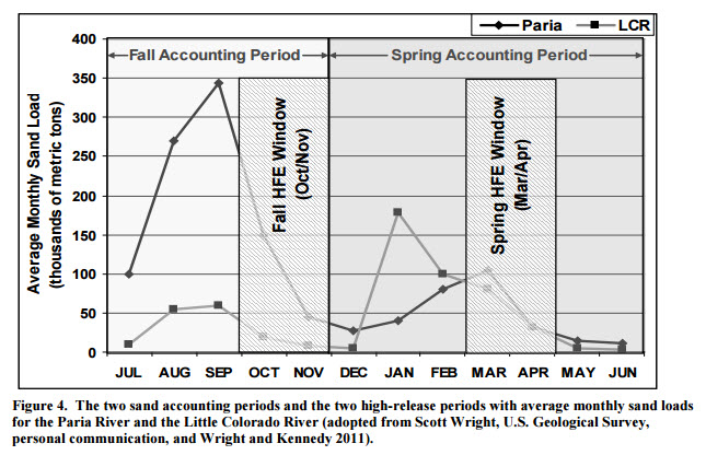
| − | + | ==Calculating the Cumulative Sand Load for an HFE== | |
| − | + | # Determine the amount of sand that has come in from the Paria River during the HFE Accounting Period you are interested in. Go to the [http://www.gcmrc.gov/discharge_qw_sediment/station/GCDAMP/09382000#/ '''Paria River gage at Lees Ferry'''] and check the Cumulative Sand Load box and enter the dates of the HFE Accounting Period. | |
| + | # Determine the amount of sand that has been transported out of Marble Canyon during the HFE accounting period by taking the lower bound value for the Cumulative Sand Load value from the [http://www.gcmrc.gov/discharge_qw_sediment/station/GCDAMP/09383050 '''Colorado River gage at 30 mile'''] and subtracting it from the lower bound value for the Cumulative Sand Load value from the [http://www.gcmrc.gov/discharge_qw_sediment/station/GCDAMP/09383100 '''Colorado River gage above the LCR''']. | ||
| + | # Subtract the amount of sand that has been transported out of Marble Canyon from the amount of sand that has come in from the Paria River and you get the amount of sand Reclamation uses for planning the HFE. | ||
| − | + | ==Calculating Magnitude and Duration of an HFE== | |
| − | + | Reclamation takes the amount of sand calculated above and subtracts the amount of sand that will be transported out of Marble Canyon between the time of the model run and the HFE. Reclamation then calculates the largest possible volume and duration release from the dam using the Scott Wright sediment transport model that does not result in a negative sand balance between the 30-mile gage and the LCR by the end of the accounting period. | |
| + | ==How much water can be released at Glen Canyon Dam?== | ||
| + | * 8 generators = ~4,000 cfs each = 30,000 cfs <br> (note that there is usually one or two generators down for maintenance at any given time) | ||
| + | * 3 bypass tubes = 5,000 cfs each = 15,000 cfs | ||
| + | * 2 spillways (require reservoir elevations above 3648') = up to 208,000 cfs | ||
---- | ---- | ||
| + | |||
| + | |||
| + | |} | ||
| + | |||
| + | <Span></Span> | ||
Revision as of 15:47, 27 September 2016
|
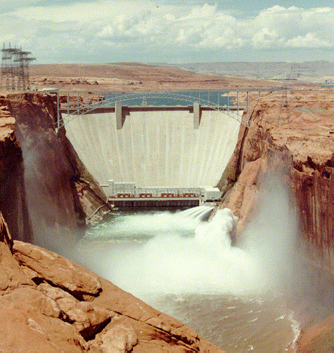
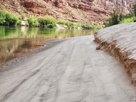
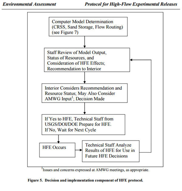
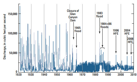
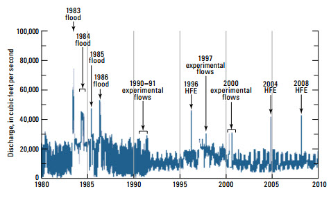
High-Flow Experimental (HFE) ReleasesConstruction and operation of dams results in numerous physical and ecological changes to river systems. Among them is the sediment carrying capacity of the river downstream of the dam. With the construction of Glen Canyon Dam, seasonal flooding that once moved sand from the riverbed to the shoreline, no longer occurs. Because more than 90 percent of the sediment that historically moved through the Grand Canyon is trapped behind the dam, the primary sources of new sand to the river system are two downstream tributaries: the Paria and Little Colorado rivers. The Operation of Glen Canyon Dam Final Environmental Impact Statement, completed in March 1995, hypothesized that controlled high-volume releases of water could be important for restoring ecological integrity downstream from the dam. Testing that hypothesis would help determine whether experimental high flows could be used to benefit important physical and biological resources in Grand Canyon National Park and Glen Canyon National Recreation Area. Such flows would also be consistent with the objectives of the 1992 Grand Canyon Protection Act (Public Law 102-575). Because controlled experimental high-flow releases to some extent mimic natural flooding, conducting such releases would provide the opportunity to evaluate the potential benefit to sediment-dependent resources including sandbars and camping beaches, marsh and riverside vegetation, and backwaters, which are near-shore areas of low-velocity flow which may be used as rearing habitat by native fish. In May 2012, the Department of the Interior implemented a new protocol for conducting multiple high-flow experimental releases through 2020, built on the 16 years of knowledge gained from prior HFEs and associated scientific research and experimentation conducted under the Adaptive management Program. The protocol provides a flexible framework to conduct HFE releases when favorable sediment conditions exist so the optimal timing, duration, frequency, and other conditions that will maximize ecological and riparian benefits downstream in Grand Canyon can be determined. The protocol identifies the conditions under which an HFE release will likely yield the greatest conservation and beneficial use of sediment deposited by inflows from Colorado River tributaries as a result of rainstorms, monsoons, and snowmelt. The ultimate goal of understanding the complexities of the interrelated ecosystem downstream of Glen Canyon Dam is a long-term challenge. The adaptive management model which emphasizes an ongoing cycle of learning through experimentation, refinement, and improvement over time, provides the appropriate framework to achieve this understanding. Through the Glen Canyon Dam Adaptive Management Program, continued implementation of HFEs as a key operational strategy will yield invaluable knowledge about the response of, and benefit to downstream resources. [1] |
| --- | --- | --- |
|---|
|
|
