Difference between revisions of "The -12 Mile Slough"
Cellsworth (Talk | contribs) |
Cellsworth (Talk | contribs) |
||
| (5 intermediate revisions by the same user not shown) | |||
| Line 38: | Line 38: | ||
|class="MainPageBG" style="width:55%; border:1px solid #cef2e0; background:#f5faff; vertical-align:top; color:#000;"| | |class="MainPageBG" style="width:55%; border:1px solid #cef2e0; background:#f5faff; vertical-align:top; color:#000;"| | ||
{|width="100%" cellpadding="2" cellspacing="5" style="vertical-align:top; background:#f5faff;" | {|width="100%" cellpadding="2" cellspacing="5" style="vertical-align:top; background:#f5faff;" | ||
| − | ! <h2 style="margin:0; background:#cedff2; font-size:120%; font-weight:bold; border:1px solid #a3bfb1; text-align:left; color:#000; padding:0.2em 0.4em;"> | + | ! <h2 style="margin:0; background:#cedff2; font-size:120%; font-weight:bold; border:1px solid #a3bfb1; text-align:left; color:#000; padding:0.2em 0.4em;">Is the slough a historical feature?</h2> |
|- | |- | ||
|style="color:#000;"| | |style="color:#000;"| | ||
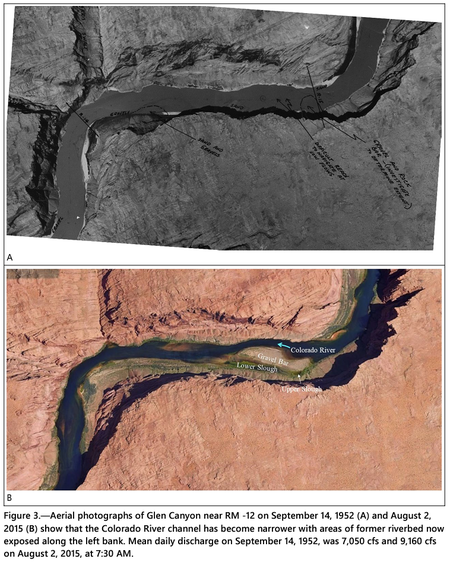
Following the closure of Glen Canyon Dam in 1963, Lake Powell began trapping sediment that resulted in erosion of the Colorado River channel through Glen Canyon creating a narrower and deeper channel (Pemberton, 1976, and Grams et al, 2007). Near RM -12, the channel thalweg has lowered 10 ft and the water surface elevation has lowered 5 ft subsequent to 1959 (Grams et al, 2007 see figure 9 of that report). Notations on a 1952 aerial photograph indicate that the left side of the river channel was shallow with a submerged “gravel and rock bar” at the upstream end and a sandbar at the downstream end (Figure 3A). In other words, the upper and lower slough as they exist today did not exist prior to the dam. After many years of streambed erosion, the channel became deeper along the right side of the canyon while the left side of the former riverbed became exposed as a high gravel bar. Depressions on the left side of the exposed gravel bar now function as the upper and lower sloughs (Figure 3B). [https://www.usbr.gov/uc/progact/amp/amwg/2023-08-17-amwg-meeting/20230817-GlenCanyonSloughProposedModifications-508-UCRO.pdf] | Following the closure of Glen Canyon Dam in 1963, Lake Powell began trapping sediment that resulted in erosion of the Colorado River channel through Glen Canyon creating a narrower and deeper channel (Pemberton, 1976, and Grams et al, 2007). Near RM -12, the channel thalweg has lowered 10 ft and the water surface elevation has lowered 5 ft subsequent to 1959 (Grams et al, 2007 see figure 9 of that report). Notations on a 1952 aerial photograph indicate that the left side of the river channel was shallow with a submerged “gravel and rock bar” at the upstream end and a sandbar at the downstream end (Figure 3A). In other words, the upper and lower slough as they exist today did not exist prior to the dam. After many years of streambed erosion, the channel became deeper along the right side of the canyon while the left side of the former riverbed became exposed as a high gravel bar. Depressions on the left side of the exposed gravel bar now function as the upper and lower sloughs (Figure 3B). [https://www.usbr.gov/uc/progact/amp/amwg/2023-08-17-amwg-meeting/20230817-GlenCanyonSloughProposedModifications-508-UCRO.pdf] | ||
| − | |||
| − | |||
[[file:Aerialslough.png|thumb|center|450px|]] <br> | [[file:Aerialslough.png|thumb|center|450px|]] <br> | ||
| + | |||
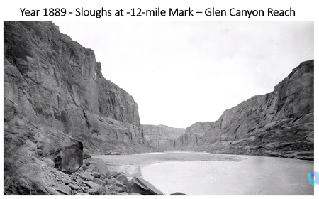
| + | The 1889 photo, captured 74 years before 1963 dam completion, shows a sandbar and a distant backwater that have persisted in various forms during the past 135 years or longer. The bar is composed of sand with no vegetation, suggesting a more dynamic river with high spring season flows and summer monsoon flash floods, which at times flowed over the bar. The 2011 photo, captured 61 years after dam completion, shows the slough site with cobble and vegetation growth, suggesting a less dynamic river with less frequent flows of water over the bar. During the 135-year period, the general shape of the bar and lower slough backwater remain similar, even though river flows at times covered the entire slough and bar with high water flows. [https://parkplanning.nps.gov/document.cfm?parkID=62&projectID=123839&documentID=139804] | ||
| + | |||
| + | [[file:1889slough.png|thumb|center|450px|]] <br> | ||
|- | |- | ||
| Line 60: | Line 62: | ||
Action is needed to disrupt or prevent the establishment of high-risk (predatory) warmwater nonnative fish in the proposed project area by limiting additional recruitment before the 2025 reproductive season and beyond. Warmwater nonnative fish threaten populations of the federally listed fish species humpback chub and razorback sucker and other native fish, amphibians, and invertebrates in Glen Canyon, Marble Canyon, and Grand Canyon. [https://parkplanning.nps.gov/document.cfm?parkID=62&projectID=123839&documentID=139804] | Action is needed to disrupt or prevent the establishment of high-risk (predatory) warmwater nonnative fish in the proposed project area by limiting additional recruitment before the 2025 reproductive season and beyond. Warmwater nonnative fish threaten populations of the federally listed fish species humpback chub and razorback sucker and other native fish, amphibians, and invertebrates in Glen Canyon, Marble Canyon, and Grand Canyon. [https://parkplanning.nps.gov/document.cfm?parkID=62&projectID=123839&documentID=139804] | ||
| − | |||
| − | |||
[[file:SloughModification.png|thumb|center|450px|]] <br> | [[file:SloughModification.png|thumb|center|450px|]] <br> | ||
| + | |||
| + | |- | ||
| + | ! <h2 style="margin:0; background:#cedff2; font-size:120%; font-weight:bold; border:1px solid #a3b0bf; text-align:left; color:#000; padding:0.2em 0.4em;">The Slough Spring</h2> | ||
| + | |- | ||
| + | |style="color:#000;"| | ||
| + | |||
| + | [[file:SloughSpring.png|thumb|center|450px|]] <br> | ||
|} | |} | ||
| Line 87: | Line 94: | ||
*[https://parkplanning.nps.gov/projectHome.cfm?parkID=62&projectID=123839 NPS EA Page: Warm Water Invasive Fish Management at the -12 Mile Slough] | *[https://parkplanning.nps.gov/projectHome.cfm?parkID=62&projectID=123839 NPS EA Page: Warm Water Invasive Fish Management at the -12 Mile Slough] | ||
*[https://parkplanning.nps.gov/document.cfm?parkID=62&projectID=123839&documentID=139804 2024 NPS Slough EA: Warmwater Nonnative Fish Management Plan / Environmental Assessment ] | *[https://parkplanning.nps.gov/document.cfm?parkID=62&projectID=123839&documentID=139804 2024 NPS Slough EA: Warmwater Nonnative Fish Management Plan / Environmental Assessment ] | ||
| + | *[https://parkplanning.nps.gov/document.cfm?parkID=62&projectID=123839&documentID=142181 Finding of No Significant Impact (FONSI) for the Warmwater Nonnative Fish Management at the -12-Mile Slough Environmental Assessment] | ||
*[https://www.usbr.gov/uc/progact/amp/amwg/2023-08-17-amwg-meeting/20230817-GlenCanyonSloughProposedModifications-508-UCRO.pdf 2023 Reclamation Proposed Modifications Report for Glen Canyon Sloughs] | *[https://www.usbr.gov/uc/progact/amp/amwg/2023-08-17-amwg-meeting/20230817-GlenCanyonSloughProposedModifications-508-UCRO.pdf 2023 Reclamation Proposed Modifications Report for Glen Canyon Sloughs] | ||
| Line 94: | Line 102: | ||
|style="color:#000;"| | |style="color:#000;"| | ||
| + | *[[Media:ZUNITHPO_LETTER_TO_AZSHPO_-12MILESLOUGHNPSACTION_13DECEMBER2024.pdf|Zuni THIO Letter to AZ SHPO regarding the -12 Mile Slough Modification]] | ||
*[https://www.usbr.gov/uc/progact/amp/twg/2024-01-25-twg-meeting/20240125-TWGMeeting-GlenCanyonNRA-508-UCRO.pdf Glen Canyon NRA - Update on 12-mile Slough Discussions and Actions ] | *[https://www.usbr.gov/uc/progact/amp/twg/2024-01-25-twg-meeting/20240125-TWGMeeting-GlenCanyonNRA-508-UCRO.pdf Glen Canyon NRA - Update on 12-mile Slough Discussions and Actions ] | ||
*[https://www.usbr.gov/uc/progact/amp/twg/2023-11-08-twg-meeting/20231108-GlenCanyonReach%E2%80%93GlenCanyonNRAUpdateSloughChemicalTreatment-508-UCRO.pdf Glen Canyon Reach – Glen Canyon NRA Update: Slough Chemical Treatment] | *[https://www.usbr.gov/uc/progact/amp/twg/2023-11-08-twg-meeting/20231108-GlenCanyonReach%E2%80%93GlenCanyonNRAUpdateSloughChemicalTreatment-508-UCRO.pdf Glen Canyon Reach – Glen Canyon NRA Update: Slough Chemical Treatment] | ||
Latest revision as of 12:37, 4 February 2025
|
|
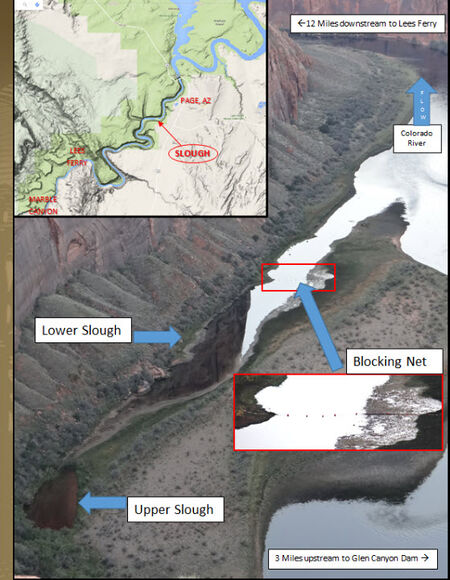
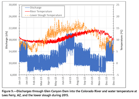
Two sloughs associated with a gravel bar that is 3.5 river miles downstream from Glen Canyon Dam or 12 river miles upstream from Lees Ferry, Arizona (AZ) (RM -12; Figure 1) are warmer than the Colorado River for much of the year creating habitat for warmwater non-native fishes. The lower (downstream) slough has a surface water connection with the Colorado River. However, the upper (upstream) slough is normally only connected with the Colorado River via groundwater through the sediments of the gravel bar (Figure 2). Darcy’s Law suggests this groundwater connection takes weeks to exchange water with the upper slough. At a river discharge of at least 20,000 cubic-feet-per-second (cfs; high end of daily fluctuating flow) water flows over the gravel bar and establishes a temporary surface water connection between the Colorado River and the upper slough. [1] |
| -- |
-- |
-- |
|---|
|
|
