Difference between revisions of "GCDAMP Sediment"
Cellsworth (Talk | contribs) |
Cellsworth (Talk | contribs) |
||
| Line 100: | Line 100: | ||
*[https://www.gcmrc.gov/research_areas/sediment_geomorphology/sed/Sed_Geomorph_storage.aspx Sediment Storage] | *[https://www.gcmrc.gov/research_areas/sediment_geomorphology/sed/Sed_Geomorph_storage.aspx Sediment Storage] | ||
*[https://www.gcmrc.gov/research_areas/sediment_geomorphology/sed/Sed_Geomorph_Home_Page.aspx Underwater Photography to Measure Bed Grain Size ] | *[https://www.gcmrc.gov/research_areas/sediment_geomorphology/sed/Sed_Geomorph_Home_Page.aspx Underwater Photography to Measure Bed Grain Size ] | ||
| − | |||
| − | |||
| − | |||
| − | |||
| − | |||
| − | |||
| − | |||
| − | |||
| − | |||
| − | |||
| − | |||
| − | |||
| − | |||
| − | |||
| − | |||
| − | |||
| − | |||
| − | |||
| − | |||
| − | |||
| − | |||
| − | |||
| − | |||
| − | |||
| − | |||
| − | |||
| − | |||
| − | |||
| − | |||
| − | |||
|- | |- | ||
| Line 182: | Line 152: | ||
'''2011''' | '''2011''' | ||
*[http://www.usbr.gov/uc/rm/amp/amwg/mtgs/11aug24/Attach_06.pdf GCMRC update on Chub, Temperature, and Sediment] | *[http://www.usbr.gov/uc/rm/amp/amwg/mtgs/11aug24/Attach_06.pdf GCMRC update on Chub, Temperature, and Sediment] | ||
| + | |||
| + | |- | ||
| + | ! <h2 style="margin:0; background:#cedff2; font-size:120%; font-weight:bold; border:1px solid #a3b0bf; text-align:left; color:#000; padding:0.2em 0.4em;">Sediment Gages</h2> | ||
| + | |- | ||
| + | |style="color:#000;"| | ||
| + | |||
| + | *[http://www.gcmrc.gov/discharge_qw_sediment/station/GCDAMP/09382000#/ Paria River at Lees Ferry] | ||
| + | *[http://www.gcmrc.gov/discharge_qw_sediment/station/GCDAMP/09380000 Colorado River at Lees Ferry] | ||
| + | *[http://www.gcmrc.gov/discharge_qw_sediment/station/GCDAMP/09383050 Colorado River at 30 mile] | ||
| + | *[http://www.gcmrc.gov/discharge_qw_sediment/station/GCDAMP/09383100 Colorado River above LCR] | ||
| + | *[http://www.gcmrc.gov/discharge_qw_sediment/station/GCDAMP/09403000 Bright Angel Creek] | ||
| + | *[http://www.gcmrc.gov/discharge_qw_sediment/station/GCDAMP/GCMRC-MCLT6 Shinumo Creek] | ||
| + | *[http://www.gcmrc.gov/discharge_qw_sediment/station/GCDAMP/09402352 Colorado River abv Lava Canyon rm66] | ||
| + | *[http://www.gcmrc.gov/discharge_qw_sediment/station/GCDAMP/09403270 Colorado River bl rm127] | ||
| + | *[http://www.gcmrc.gov/discharge_qw_sediment/station/GCDAMP/09403850 Kanab Creek] | ||
| + | *[http://www.gcmrc.gov/discharge_qw_sediment/station/GCDAMP/09404115 Havasu Creek] | ||
| + | *[http://www.gcmrc.gov/discharge_qw_sediment/station/GCDAMP/09404120 Colorado River abv National Canyon] | ||
| + | *[http://www.gcmrc.gov/discharge_qw_sediment/station/GCDAMP/09404200 Colorado River bl Diamond Creek] | ||
| + | *[http://www.gcmrc.gov/discharge_qw_sediment/station/GCDAMP/09404220 Colorado River abv Spencer rm246] | ||
| + | |||
| + | |- | ||
| + | ! <h2 style="margin:0; background:#cedff2; font-size:120%; font-weight:bold; border:1px solid #a3b0bf; text-align:left; color:#000; padding:0.2em 0.4em;">Sand Mass Balance Reaches in Grand Canyon </h2> | ||
| + | |- | ||
| + | |style="color:#000;"| | ||
| + | *[http://www.gcmrc.gov/discharge_qw_sediment/reach/GCDAMP/09380000/09383050 Upper Marble Canyon] | ||
| + | *[http://www.gcmrc.gov/discharge_qw_sediment/reach/GCDAMP/09383050/09383100 Lower Marble Canyon] | ||
| + | *[http://www.gcmrc.gov/discharge_qw_sediment/reach/GCDAMP/09383100/09402500 Eastern Grand Canyon] | ||
| + | *[http://www.gcmrc.gov/discharge_qw_sediment/reach/GCDAMP/09402500/09404120 East Central Grand Canyon] | ||
| + | *[http://www.gcmrc.gov/discharge_qw_sediment/reach/GCDAMP/09404120/09404200 West Central Grand Canyon] | ||
| + | *[http://www.gcmrc.gov/discharge_qw_sediment/reach/GCDAMP/09404200/Pearce%20Ferry Western Grand Canyon and the Lake Mead Delta] | ||
|- | |- | ||
Revision as of 10:38, 5 April 2017
|
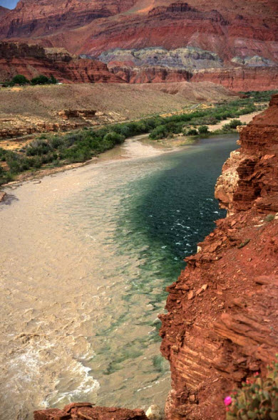
The Paria River flowing into the mainstem Colorado River |
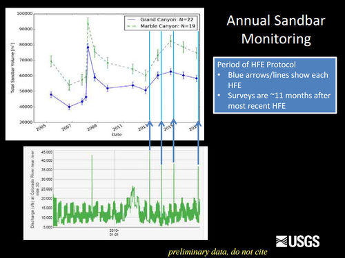
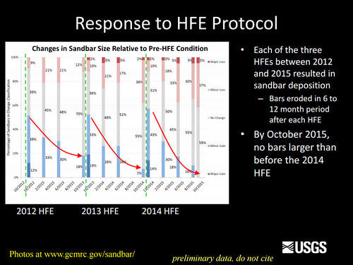
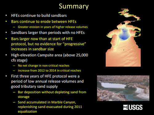
Sediment and GeomorphologyErosion of sandbars (beaches) along the Colorado River in Grand Canyon was first reported in the early 1970s, approximately 10 years after completion of Glen Canyon Dam. Since then, scientific studies have been conducted to monitor changes in sandbars and changes in the amount of sand stored on the bed of the river. One of the outcomes of these studies has been the implementation of flow experiments intended to rebuild eroded sandbars, especially by the release of controlled floods, also called High Flow Experiments, or HFEs, from Glen Canyon Dam. The sediment and geomorphology projects at Grand Canyon Monitoring and Research Center include the collection and processing of data to provide information needed to conduct controlled floods and to evaluate the outcome of each controlled flood and the long-term effects of controlled floods and normal dam operations on sediment-related resources. [1] Beginning in 1998, recreational campsite area has also been measured on a subset of the sandbar monitoring sites. Campsite areas are defined as areas that are flat (less than 8 degree slope), smooth (not rocky), and clear of dense vegetation. Monitoring data show that vegetation expansion and sandbar erosion/deposition contribute to reductions in campsite area.
Desired Future Condition for Sediment-Related ResourcesHigh elevation open riparian sediment deposits along the Colorado River in sufficient volume, area, and distribution so as to provide habitat to sustain native biota and desired ecosystem processes |
| --- |
--- |
--- |
|---|


