Updates
|
|
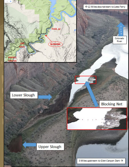
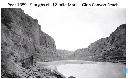
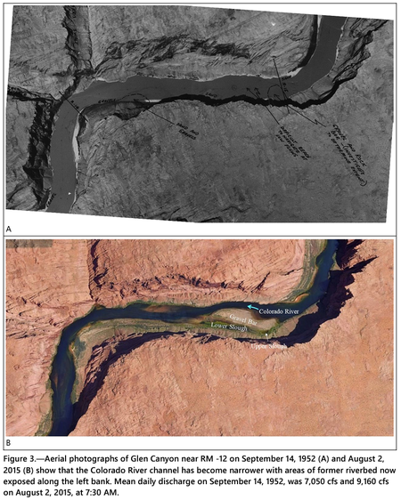
Following the closure of Glen Canyon Dam in 1963, Lake Powell began trapping sediment that resulted in erosion of the Colorado River channel through Glen Canyon creating a narrower and deeper channel (Pemberton, 1976, and Grams et al, 2007). Near RM -12, the channel thalweg has lowered 10 ft and the water surface elevation has lowered 5 ft subsequent to 1959 (Grams et al, 2007 see figure 9 of that report). Notations on a 1952 aerial photograph indicate that the left side of the river channel was shallow with a submerged “gravel and rock bar” at the upstream end and a sandbar at the downstream end (Figure 3A). In other words, the upper and lower slough as they exist today did not exist prior to the dam. After many years of streambed erosion, the channel became deeper along the right side of the canyon while the left side of the former riverbed became exposed as a high gravel bar. Depressions on the left side of the exposed gravel bar now function as the upper and lower sloughs (Figure 3B). [2]
|
|
Links
|
|
|
Documents
|
|
|
Presentations and Papers
|
|
|
Rotenone Treatments
|
- November 2-6, 2015: rotenone treatment for green sunfish
- September 17-19, 2022: rotenone treatment for smallmouth bass
- August 25-28, 2023: herbicide treatment for smallmouth bass
|
Slough Temperatures
|
|
The slough is only exposed to the sun from February to November. The rest of the year the sun is behind the rim of the canyon.
- November-February: no sun
- April: 4 hours
- May: 11 hrs
- June-August: 11.5 hrs
- September: 4 hrs
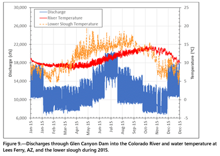
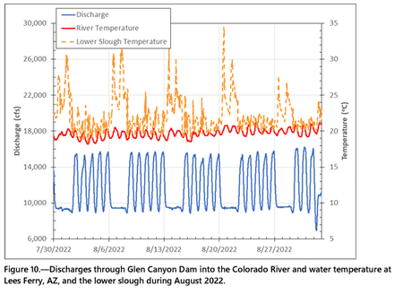
Upper slough water temperatures are more susceptible to seasonal fluctuations than the river. Water temperatures in the upper slough typically become even colder than the river water during the winter because there is not normally a surface water connection between the river and upper slough during this time of the year. The reverse pattern happens during the summer when the slough water temperatures warm with the air temperature. Discharge and temperature data from 2015 show that water temperatures in the lower slough vary with season and with river discharge (Figure 9). Water temperatures in the slough were colder than the river water during that year in January, February, much of March, November, and December. However, water temperatures in the lower slough were significantly warmer than the river channel during May, June, July, August, and September. Similar trends were observed in other abbreviated data sets provided by the National Park Service for 2013 through 2017, and 2022. Additionally, discharge and temperature data from August 2022 show that water temperatures in the lower slough were significantly warmer during weekends when the discharges are relatively steady, indicating that daily discharge fluctuations during the week exchange water with the lower slough and limit warming (Figure 10). [3]
|
|
