Difference between revisions of "GCDAMP Sediment"
(add http://www.usbr.gov/uc/rm/amp/amwg/mtgs/02jan17/Attach_10a.pdf) |
Cellsworth (Talk | contribs) |
||
| (188 intermediate revisions by 2 users not shown) | |||
| Line 12: | Line 12: | ||
<tr style='mso-yfti-irow:0;mso-yfti-firstrow:yes'> | <tr style='mso-yfti-irow:0;mso-yfti-firstrow:yes'> | ||
<td width=40% valign=bottom align=left style='width:2.05in;padding:0in 5.4pt 0in 5.4pt'> | <td width=40% valign=bottom align=left style='width:2.05in;padding:0in 5.4pt 0in 5.4pt'> | ||
| − | <p class=MsoNormal> | + | <p class=MsoNormal></p> |
</td> | </td> | ||
</tr> | </tr> | ||
</table> | </table> | ||
| + | |||
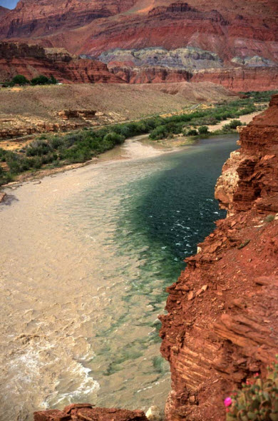
| + | [[File:Paria at mainstem.jpg|center|thumbnail|400px|The Paria River flowing into the mainstem Colorado River]]<br> | ||
| + | |||
<!-- | <!-- | ||
------------Portal list on righthand side----------> | ------------Portal list on righthand side----------> | ||
| − | |style="width:60%; font-size: | + | |style="width:60%; font-size:120%;"| |
| − | ''' | + | |
| + | ==[http://www.gcmrc.gov/research_areas/sediment_geomorphology/sed/Sed_Geomorph_Home_Page.aspx '''Sediment and Geomorphology''']== | ||
| + | |||
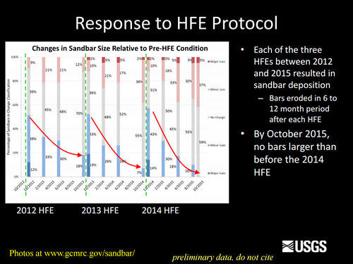
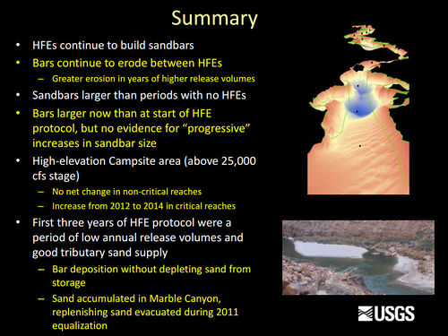
| + | Erosion of sandbars (beaches) along the Colorado River in Grand Canyon was first reported in the early 1970s, approximately 10 years after completion of Glen Canyon Dam. Since then, scientific studies have been conducted to monitor changes in sandbars and changes in the amount of sand stored on the bed of the river. One of the outcomes of these studies has been the implementation of flow experiments intended to rebuild eroded sandbars, especially by the release of controlled floods, also called [http://gcdamp.com/index.php?title=The_HFE_Page '''High Flow Experiments, or HFEs,'''] from Glen Canyon Dam. The sediment and geomorphology projects at Grand Canyon Monitoring and Research Center include the collection and processing of data to provide information needed to conduct controlled floods and to evaluate the outcome of each controlled flood and the long-term effects of controlled floods and normal dam operations on sediment-related resources. [https://www.gcmrc.gov/research_areas/sediment_geomorphology/sed/Sed_Geomorph_Home_Page.aspx] | ||
| + | |||
| + | Beginning in 1998, [http://gcdamp.com/index.php?title=RECREATION '''recreational campsite area'''] has also been measured on a subset of the sandbar monitoring sites. Campsite areas are defined as areas that are flat (less than 8 degree slope), smooth (not rocky), and clear of dense vegetation. Monitoring data show that vegetation expansion and sandbar erosion/deposition contribute to reductions in campsite area. | ||
| + | ==[http://gcdamp.com/index.php?title=Long-term_Experimental_and_Management_Plan_(LTEMP) '''LTEMP Resource Goal for Sediment''']== | ||
| + | Increase and retain fine sediment volume, area, and distribution in | ||
| + | the Glen, Marble, and Grand Canyon reaches above the elevation of the | ||
| + | average base flow for ecological, cultural, and recreational purposes. | ||
| + | ==[http://gcdamp.com/index.php?title=Portal:Desired_Future_Conditions_-DFCs '''Desired Future Condition for Sediment-Related Resources''']== | ||
| + | High elevation open riparian sediment deposits along the Colorado River in sufficient volume, area, and distribution so as to provide habitat to sustain native biota and desired ecosystem processes<br> | ||
| + | • Nearshore habitats for native fish<br> | ||
| + | • Marsh and riparian habitat for fish (food chain maintenance)<br> | ||
| + | • Cultural resource preservation<br> | ||
| + | • Maintenance of camping beaches<br> | ||
|}<!-- | |}<!-- | ||
----------Strapline immediately below banner----------> | ----------Strapline immediately below banner----------> | ||
{| style="width:100%; height:50px" border=1px solid #ccc; background:#cedff2 | {| style="width:100%; height:50px" border=1px solid #ccc; background:#cedff2 | ||
| − | ! style="width=33%; background:#cedff2;" | [[TBD| | + | ! style="width=33%; background:#cedff2;" | [[TBD|---]]<br> |
| − | ! style="width=33%; background:#cedff2;" | [[TBD| | + | ! style="width=33%; background:#cedff2;" | [[TBD|---]]<br> |
| − | + | ! style="width=33%; background:#cedff2;" | [[TBD|---]]<br> | |
| − | ! style="width=33%; background:#cedff2;" | [[TBD| | + | |
|} | |} | ||
| Line 37: | Line 54: | ||
|class="MainPageBG" style="width:55%; border:1px solid #cef2e0; background:#f5faff; vertical-align:top; color:#000;"| | |class="MainPageBG" style="width:55%; border:1px solid #cef2e0; background:#f5faff; vertical-align:top; color:#000;"| | ||
{|width="100%" cellpadding="2" cellspacing="5" style="vertical-align:top; background:#f5faff;" | {|width="100%" cellpadding="2" cellspacing="5" style="vertical-align:top; background:#f5faff;" | ||
| − | ! <h2 style="margin:0; background:#cedff2; font-size:120%; font-weight:bold; border:1px solid #a3bfb1; text-align:left; color:#000; padding:0.2em 0.4em;"> | + | ! <h2 style="margin:0; background:#cedff2; font-size:120%; font-weight:bold; border:1px solid #a3bfb1; text-align:left; color:#000; padding:0.2em 0.4em;">Updates</h2> |
| − | + | ||
|- | |- | ||
|style="color:#000;"| | |style="color:#000;"| | ||
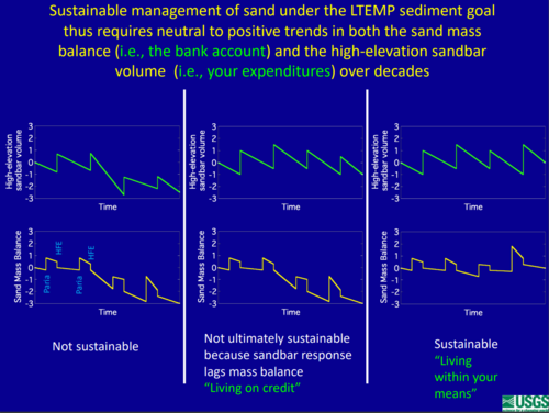
| − | | | + | [[File:SedimentSustainability.PNG|center|thumbnail|500px|https://www.usbr.gov/uc/progact/amp/twg/2022-01-13-twg-meeting/20220113-AnnualReportingMeeting-ProjectA-StreamflowWaterQualitySedimentTransportBudgetingColoradoRiverEcosystem-508-UCRO.pdf ]] |
| − | + | ||
| − | + | ||
| − | + | ||
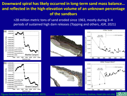
| + | [[File:LongtermDecline.PNG|center|thumbnail|500px|https://www.usbr.gov/uc/progact/amp/twg/2022-01-13-twg-meeting/20220113-AnnualReportingMeeting-ProjectA-StreamflowWaterQualitySedimentTransportBudgetingColoradoRiverEcosystem-508-UCRO.pdf ]] | ||
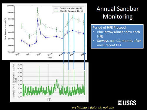
| − | + | [[File:SandbarMonitoring2016.jpg|center|thumbnail|500px|[https://www.usbr.gov/uc/rm/amp/twg/mtgs/17jan26/AR3_Grams.pdf https://www.usbr.gov/uc/rm/amp/twg/mtgs/17jan26/AR3_Grams.pdf] ]] | |
| − | + | ||
| − | + | ||
| − | + | ||
| + | [[File:2012 2014 HFE response.jpg|center|thumbnail|500px|[https://www.usbr.gov/uc/rm/amp/twg/mtgs/15jun11/Attach_02,.pdf https://www.usbr.gov/uc/rm/amp/twg/mtgs/15jun11/Attach_02,.pdf] ]] | ||
| − | | | + | [[File:2016 SedimentSummary.jpg|center|thumbnail|500px|[https://www.usbr.gov/uc/rm/amp/twg/mtgs/16jan26/documents/AR02_Grams.pdf https://www.usbr.gov/uc/rm/amp/twg/mtgs/16jan26/documents/AR02_Grams.pdf] ]] |
| + | |- | ||
| + | ! <h2 style="margin:0; background:#cedff2; font-size:120%; font-weight:bold; border:1px solid #a3b0bf; text-align:left; color:#000; padding:0.2em 0.4em;"> Sediment transport and river discharge </h2> | ||
| + | |- | ||
| + | |style="color:#000;"| | ||
| + | When the discharge of the Colorado River was lower than about 9,000 ft3/s, sand accumulated in the reach in Marble and upper Grand Canyons. At discharges higher than about 9,000 ft3/s, however, sand-transport rates at the Grand Canyon gaging station generally equaled those at the Lees Ferry gaging station, and at discharges higher than about 16,000 ft3/s, sand-transport rates at the Grand Canyon gaging station generally either equaled or exceeded those at the Lees Ferry gaging station. Thus, at discharges greater than about 9,000 ft3/s, sand was either conveyed through or eroded from the reach in Marble and upper Grand Canyons. | ||
| + | As discharges less than 9,000 ft3/s became less common, the discharge of the river became progressively more conducive to the conveyance of sand through or the erosion of sand from Marble and upper Grand Canyons. [https://pubs.usgs.gov/pp/pp1677/pdf/pp1677.pdf] | ||
| + | |} | ||
| + | <!-- | ||
| + | |class="MainPageBG" style="width:45%; border:1px solid #cedff2; background:#f5faff; vertical-align:top;"| | ||
| + | {| width="100%" cellpadding="2" cellspacing="5" style="vertical-align:top; background:#f5faff;" | ||
| + | ! <h2 style="margin:0; background:#cedff2; font-size:120%; font-weight:bold; border:1px solid #a3b0bf; text-align:left; color:#000; padding:0.2em 0.4em;">Information</h2> | ||
| + | |- | ||
| + | |style="color:#000;"| | ||
| + | *[http://www.gcmrc.gov/discharge_qw_sediment/station/GCDAMP/09382000#/ '''Paria River sediment gage'''] Click here to calculate how much sediment has come in from the Paria River. | ||
| + | *[[GCDAMP The_HFE_Page '''The HFE Page''']] See summaries from past HFEs | ||
| + | |- | ||
| − | |||
| − | |||
--------------------------------ADDITIONAL-------------------------------> | --------------------------------ADDITIONAL-------------------------------> | ||
|class="MainPageBG" style="width:45%; border:1px solid #cedff2; background:#f5faff; vertical-align:top;"| | |class="MainPageBG" style="width:45%; border:1px solid #cedff2; background:#f5faff; vertical-align:top;"| | ||
{| width="100%" cellpadding="2" cellspacing="5" style="vertical-align:top; background:#f5faff;" | {| width="100%" cellpadding="2" cellspacing="5" style="vertical-align:top; background:#f5faff;" | ||
| − | ! <h2 style="margin:0; background:#cedff2; font-size:120%; font-weight:bold; border:1px solid #a3b0bf; text-align:left; color:#000; padding:0.2em 0.4em;">Information</h2> | + | ! <h2 style="margin:0; background:#cedff2; font-size:120%; font-weight:bold; border:1px solid #a3b0bf; text-align:left; color:#000; padding:0.2em 0.4em;">Links and Information</h2> |
|- | |- | ||
|style="color:#000;"| | |style="color:#000;"| | ||
| − | * | + | |
| − | * | + | *[http://gcdamp.com/index.php?title=Portal:GCDAMP_Knowlege_Assessments GCMRC Annual Reports page] |
| − | * | + | *[https://www.gcmrc.gov/sandbar/ GCMRC Grand Canyon Sandbar Monitoring] |
| − | * | + | *[http://gcdamp.com/index.php?title=The_HFE_Page The High Flow Experiment (HFE) Page] |
| − | * | + | *[http://gcdamp.com/index.php?title=RECREATION Recreation Page] |
| + | *[[Aeolian Sand Transport| Aeolian Sand Transport Page]] | ||
| + | *[http://gcdamp.com/index.php?title=Turbidity Turbidity Page] | ||
| + | *[http://gcdamp.com/index.php?title=GCDAMP-_Over-Flights Over Flights Page] | ||
|- | |- | ||
| − | ! <h2 style="margin:0; background:#cedff2; font-size:120%; font-weight:bold; border:1px solid #a3b0bf; text-align:left; color:#000; padding:0.2em 0.4em;"> | + | ! <h2 style="margin:0; background:#cedff2; font-size:120%; font-weight:bold; border:1px solid #a3b0bf; text-align:left; color:#000; padding:0.2em 0.4em;">[https://www.gcmrc.gov/research_areas/sediment_geomorphology/sed/Sed_Geomorph_Home_Page.aspx Projects]</h2> |
|- | |- | ||
|style="color:#000;"| | |style="color:#000;"| | ||
| − | *[[ | + | |
| − | * | + | *[https://www.gcmrc.gov/sandbar/ Sandbar Monitoring] |
| − | + | *[https://www.gcmrc.gov/research_areas/sediment_geomorphology/sed/Sed_Geomorph_Camp.aspx Campsite Monitoring] | |
| − | * | + | *[https://www.gcmrc.gov/discharge_qw_sediment/ Suspended Sediment Transport ] |
| − | * | + | *[https://www.gcmrc.gov/research_areas/sediment_geomorphology/sed/Sed_Geomorph_Home_Page.aspx Automated Substrate Classification Using Swath Mapping Systems] |
| + | *[https://www.gcmrc.gov/research_areas/sediment_geomorphology/sed/Sed_Geomorph_storage.aspx Sediment Storage] | ||
| + | *[https://www.gcmrc.gov/research_areas/sediment_geomorphology/sed/Sed_Geomorph_Home_Page.aspx Underwater Photography to Measure Bed Grain Size ] | ||
|- | |- | ||
| − | ! <h2 style="margin:0; background:#cedff2; font-size:120%; font-weight:bold; border:1px solid #a3b0bf; text-align:left; color:#000; padding:0.2em 0.4em;"> | + | ! <h2 style="margin:0; background:#cedff2; font-size:120%; font-weight:bold; border:1px solid #a3b0bf; text-align:left; color:#000; padding:0.2em 0.4em;">Sediment Gages</h2> |
|- | |- | ||
| + | |style="color:#000;"| | ||
| + | |||
| + | *[https://www.gcmrc.gov/discharge_qw_sediment/station/GCDAMP/GCMRC-GCLT1 Water Holes Canyon above the mouth] | ||
| + | *[https://www.gcmrc.gov/discharge_qw_sediment/station/GCDAMP/09381800 Paria River near Kanab, UT] | ||
| + | *[https://www.gcmrc.gov/discharge_qw_sediment/station/GCDAMP/09382000 Paria River at Lees Ferry, AZ] | ||
| + | *[http://www.gcmrc.gov/discharge_qw_sediment/station/GCDAMP/09380000 Colorado River at Lees Ferry] | ||
| + | *[https://www.gcmrc.gov/discharge_qw_sediment/station/GCDAMP/GCMRC-MCLT1 Badger Creek below highway 89A near Vermillion Cliffs, AZ] | ||
| + | *[https://www.gcmrc.gov/discharge_qw_sediment/station/GCDAMP/GCMRC-MCLT2 Tanner Wash below highway 89A near Bitter Springs, AZ] | ||
| + | *[https://www.gcmrc.gov/discharge_qw_sediment/station/GCDAMP/GCMRC-MCLT3 House Rock Wash above Emmett Wash near Cliff Dwellers, AZ] | ||
| + | *[https://www.gcmrc.gov/discharge_qw_sediment/station/GCDAMP/GCMRC-MCLT5 North Canyon near Cliff Dwellers, AZ] | ||
| + | *[https://www.gcmrc.gov/discharge_qw_sediment/station/GCDAMP/GCMRC-MCLT6 Shinumo Wash in Twentynine Mile Canyon near Cedar Ridge, AZ] | ||
| + | *[http://www.gcmrc.gov/discharge_qw_sediment/station/GCDAMP/09383050 Colorado River near river mile 30] | ||
| + | *[http://www.gcmrc.gov/discharge_qw_sediment/station/GCDAMP/09383100 Colorado River above Little Colorado River near Desert View, AZ] | ||
| + | *[https://www.gcmrc.gov/discharge_qw_sediment/station/GCDAMP/09401500 Moenkopi Wash near Cameron, AZ] | ||
| + | *[https://www.gcmrc.gov/discharge_qw_sediment/station/GCDAMP/09401000 Little Colorado River at Grand Falls, AZ] | ||
| + | *[https://www.gcmrc.gov/discharge_qw_sediment/station/GCDAMP/09401200 Little Colorado River at Cameron, AZ] | ||
| + | *[https://www.gcmrc.gov/discharge_qw_sediment/station/GCDAMP/09402000 Little Colorado River near Cameron, AZ] | ||
| + | *[https://www.gcmrc.gov/discharge_qw_sediment/station/GCDAMP/09402300 Little Colorado River above the mouth near Desert View, AZ] | ||
| + | *[https://www.gcmrc.gov/discharge_qw_sediment/station/GCDAMP/09402500 Colorado River near Grand Canyon, AZ] | ||
| + | *[http://www.gcmrc.gov/discharge_qw_sediment/station/GCDAMP/09403000 Bright Angel Creek near Grand Canyon, AZ] | ||
| + | *[http://www.gcmrc.gov/discharge_qw_sediment/station/GCDAMP/GCMRC-MCLT6 Shinumo Creek] | ||
| + | *[http://www.gcmrc.gov/discharge_qw_sediment/station/GCDAMP/09403850 Kanab Creek above the mouth near Supai, AZ] | ||
| + | *[http://www.gcmrc.gov/discharge_qw_sediment/station/GCDAMP/09404115 Havasu Creek above the mouth near Supai, AZ] | ||
| + | *[http://www.gcmrc.gov/discharge_qw_sediment/station/GCDAMP/09404120 Colorado River above National Canyon near Supai, AZ] | ||
| + | *[http://www.gcmrc.gov/discharge_qw_sediment/station/GCDAMP/09404200 Colorado River above Diamond Creek near Peach Springs, AZ] | ||
| + | |||
| + | |- | ||
| + | ! <h2 style="margin:0; background:#cedff2; font-size:120%; font-weight:bold; border:1px solid #a3b0bf; text-align:left; color:#000; padding:0.2em 0.4em;">Sand Mass Balance Reaches in Grand Canyon </h2> | ||
| + | |- | ||
| + | |style="color:#000;"| | ||
| + | *[http://www.gcmrc.gov/discharge_qw_sediment/reach/GCDAMP/09380000/09383050 Upper Marble Canyon] | ||
| + | *[http://www.gcmrc.gov/discharge_qw_sediment/reach/GCDAMP/09383050/09383100 Lower Marble Canyon] | ||
| + | *[http://www.gcmrc.gov/discharge_qw_sediment/reach/GCDAMP/09383100/09402500 Eastern Grand Canyon] | ||
| + | *[http://www.gcmrc.gov/discharge_qw_sediment/reach/GCDAMP/09402500/09404120 East Central Grand Canyon] | ||
| + | *[http://www.gcmrc.gov/discharge_qw_sediment/reach/GCDAMP/09404120/09404200 West Central Grand Canyon] | ||
| + | *[http://www.gcmrc.gov/discharge_qw_sediment/reach/GCDAMP/09404200/Pearce%20Ferry Western Grand Canyon and the Lake Mead Delta] | ||
| + | |||
| + | |- | ||
| + | ! <h2 style="margin:0; background:#cedff2; font-size:120%; font-weight:bold; border:1px solid #a3b0bf; text-align:left; color:#000; padding:0.2em 0.4em;"> Presentations and Papers </h2> | ||
| + | |- | ||
| + | |style="color:#000;"| | ||
| + | |||
| + | '''2024''' | ||
| + | *[https://www.usbr.gov/uc/progact/amp/amwg/2024-02-29-amwg-meeting/20240229-ProjectB-UpdateRiverbedSandbarResponseDamOperationsHFE-508-UCRO.pdf Project B Update and Riverbed and sandbar response to dam operations and high-flow experiments ] | ||
| + | *[https://www.usbr.gov/uc/progact/amp/amwg/2024-02-29-amwg-meeting/20240229-ProjectA-StreamflowWaterQualitySedimentTransportBudgetingColoradoRiverEcosystem-508-UCRO.pdf Project A: Streamflow, Water Quality, and Sediment Transport and Budgeting in the Colorado River Ecosystem ] | ||
| + | *[https://www.usbr.gov/uc/progact/amp/twg/2024-01-25-twg-meeting/20240125-AnnualReportingMeeting-EffectsDamOperationsVegetationManagementPreservationGeomorphicConditionArchaeologicalSites-508-UCRO.pdf Effects of Reservoirs and Stock Ponds on Surface Water Runoff in the Little Colorado River Basin ] | ||
| + | *[[Media:Sartain_AGU2023_poster_ARM.pdf| Assessing geomorphic change for 454 river km of the Colorado River in Grand Canyon, AZ via continuous and high-resolution water surface and bed profiles | ||
| + | ]] | ||
| + | *[[Media:Kaplinski_Glen_canyon_flow_model_poster_20240114.pdf| Hydrodynamic modeling of the Colorado River between Glen Canyon Dam and Lees Ferry, Arizona]] | ||
| + | |||
| + | '''2024''' | ||
| + | *[https://www.usbr.gov/uc/progact/amp/twg/2024-01-25-twg-meeting/20240125-AnnualReportingMeeting-ChannelResponseHighFlowsWesternGrandCanyon-508-UCRO.pdf Channel Response to High Flows in Western Grand Canyon ] | ||
| + | *[https://www.usbr.gov/uc/progact/amp/twg/2024-01-25-twg-meeting/20240125-AnnualReportingMeeting-ProjectAStreamflowWaterQualitySedimentTransportBudgetingColoradoRiverEcosystem-508-UCRO.pdf Project A: Streamflow, Water Quality, and Sediment Transport and Budgeting in the Colorado River Ecosystem ] | ||
| + | *[https://www.usbr.gov/uc/progact/amp/twg.html#:~:text=Project%20B%20Update%20and%20Riverbed%20and%20sandbar%20response%20to%20dam%20operations%20and%20high%2Dflow%20experiments Project B Update and Riverbed and sandbar response to dam operations and high-flow experiments ] | ||
| + | |||
| + | '''2023''' | ||
| + | *[https://www.usbr.gov/uc/progact/amp/twg/2023-01-26-twg-meeting/20230126-AnnualReportingMeeting-AContinuousHigh-ResolutionProfileRiverbedWaterSurface460-kmColoradoRiverGrandCanyon-508-UCRO.pdf A Continuous High-Resolution Profile of the Riverbed and Water Surface for 460-km of the Colorado River in Grand Canyon] | ||
| + | *[https://www.usbr.gov/uc/progact/amp/twg/2023-01-26-twg-meeting/20230126-AnnualReportingMeeting-StreamflowSedimentVegetationDynamics-508-UCRO.pdf Project A: Streamflow, Sediment, and Vegetation Dynamics; Implications for Geomorphic Change in the Colorado River and its Tributaries] | ||
| + | *[https://www.usbr.gov/uc/progact/amp/twg/2023-01-26-twg-meeting/20230126-AnnualReportingMeeting-StreamflowWaterQualitySedimentTransportBudgetingColoradoRiverEcosystem-508-UCRO.pdf Project A: Streamflow, Water Quality, and Sediment Transport and Budgeting in the Colorado River Ecosystem] | ||
| + | *[[Media:ARM_salter.pdf| Numerical Modeling of Mud Transport, Storage, and Release on the Colorado River, Arizona]] | ||
| + | |||
| + | '''2022''' | ||
| + | *[https://www.usbr.gov/uc/progact/amp/amwg/2022-08-18-amwg-meeting/20220818-Grams_Sandbars_AMWG_BAO_508.pdf Multi-Decadal Sandbar Response to Flow Management Downstream from a Large Dam-The Glen Canyon Dam on the Colorado River in Marble and Grand Canyons, AZ ] | ||
| + | *[https://www.usbr.gov/uc/progact/amp/amwg/2022-02-10-amwg-meeting/20220210-SummarySedimentSandbarProjects-508-UCRO.pdf Summary of Sediment and Sandbar Projects GCMRC Projects A and B LTEMP Goal 7 ] | ||
| + | *[https://www.usbr.gov/uc/progact/amp/twg/2022-01-13-twg-meeting/20220113-AnnualReportingMeeting-ProjectA-StreamflowWaterQualitySedimentTransportBudgetingColoradoRiverEcosystem-508-UCRO.pdf Project A: Streamflow, Water Quality, and Sediment Transport and Budgeting in the Colorado River Ecosystem ] | ||
| + | |||
| + | '''2021''' | ||
| + | *[[Media:Glen Canyon Sand Augmentation White Paper.pdf| Argonne. 2021. Evaluation of Sand Augmentation for Stabilizing Recreational Beaches and Storing Sand in Glen Canyon National Recreation Area]] | ||
| + | *[https://www.usbr.gov/uc/progact/amp/twg/2021-10-14-twg-meeting/20211014-MorphodynamicModelEvaluateSandbarRebuilding-Presentation-508-UCRO.pdf A simple morphodynamic model to rapidly evaluate sandbar rebuilding during controlled floods] | ||
| + | *[https://doi.org/10.1029/2020JF005565 Topping et al. 2021, Self-limitation of sand storage in a bedrock-canyon river arising from the interaction of flow and grain size: Journal of Geophysical Research: Earth Surface] | ||
| + | *[https://doi.org/10.1029/2021JF006149 Alvarez et al. 2021, An eddy-resolving numerical model to study turbulent flow, sediment, and bed evolution using detached eddy simulation in a lateral separation zone at the field-scale: Journal of Geophysical Research—Earth Surface] | ||
| + | *[https://www.usbr.gov/uc/progact/amp/amwg/2021-02-11-amwg-meeting/20210211-SandSupplyTransportDeposition-508-UCRO.pdf Sand Supply, Transport and Deposition ] | ||
| + | |||
| + | '''2020''' | ||
| + | *[https://doi.org/10.1029/2019JF005226 Rubin et al., 2020, Causes of variability in suspended‐sand concentration evaluated using measurements in the Colorado River in Grand Canyon: JGR Earth Surface] | ||
| + | *[https://www.usbr.gov/uc/progact/amp/amwg/2020-02-12-amwg-meeting/20200212-GCMRCScienceUpdatesPart3-Presentation-508-UCRO.pdf GCMRC 2019 Annual Reporting Meeting Overview – Part 3 ] | ||
| + | *[https://doi.org/10.1130/B35642.1 Chapman et al., 2020, Estimating the contribution of tributary sand inputs to controlled flood deposits for sandbar restoration using elemental tracers, Colorado River, Grand Canyon National Park, Arizona: GSA Bulletin] [https://doi.org/10.5066/P9C0IN56 Associated data] | ||
| + | *[https://www.usbr.gov/uc/progact/amp/twg/2020-01-13-twg-meeting/20200113-AnnualReportingMeeting-ProjectBEffectsDamReleaseSedimentStorageSandbarDynamics-Presentation-508-UCRO.pdf Project B: Effects of dam releases on in-channel sediment storage and sandbar dynamics ] | ||
| + | *[https://doi.org/10.1029/2019WR025883 Ashley et al., 2020, Estimating bedload from suspended load and water discharge in sand bed rivers: Water Resources Research.] | ||
| + | *[https://www.usbr.gov/uc/progact/amp/twg/2020-01-13-twg-meeting/20200113-AnnualReportingMeeting-GeomorphicChangeBiogeomorphicFeedbacksLittleColoradoRiver-Presentation-508-UCRO.pdf Geomorphic Change and Biogeomorphic Feedbacks in the Little Colorado River, Arizona ] | ||
| + | |||
| + | '''2019''' | ||
| + | *[https://doi.org/10.1130/B35047.1 Dean, D.J., and Topping, D.J., 2019, Geomorphic change and biogeomorphic feedbacks in a dryland river--The Little Colorado River, Arizona, USA: GSA Bulletin ] | ||
| + | |||
| + | '''2018''' | ||
| + | *[https://qcnr.usu.edu/wats/colorado_river_studies/files/documents/Rubin.pdf Sand tells a story] | ||
| + | *[https://doi.org/10.5066/P99TN424 Sankey et al., 2018, Sand classifications along the Colorado River in Grand Canyon derived from 2002, 2009, and 2013 high-resolution multispectral airborne imagery: U.S. Geological Survey data release] | ||
| + | *[https://www.usbr.gov/uc/progact/amp/amwg/2018-08-22-amwg-meeting/Attach_12.pdf GCMRC Science Updates PPT] | ||
| + | *[https://doi.org/10.1002/rra.3349 Hadley et al., 2018, Quantifying geomorphic and vegetation change at sandbar campsites in response to flow regulation and controlled floods, Grand Canyon National Park, Arizona: River Research and Applications] | ||
| + | *[https://www.usbr.gov/uc/progact/amp/twg/2018-01-25-twg-meeting/AR02.pdf Key drivers of sand transport and storage in the Colorado River Ecosystem PPT] | ||
| + | *[https://doi.org/10.5194/hess-22-1767-2018 Voichick, N. et al., 2018, Technical note--False low turbidity readings during high suspended-sediment concentrations: Hydrology and Earth System Sciences] | ||
| + | *[https://doi.org/10.3133/ofr20181019 Grams et al., 2018, Automated remote cameras for monitoring alluvial sandbars on the Colorado River in Grand Canyon, Arizona: Open-File Report] | ||
| + | |||
| + | '''2017''' | ||
| + | *[[Media:Chapman 2017 Thesis-Determining tributary sediment exp flood deposits Marble Canyon ColRiv.pdf| Chapman, K., 2017, Determining the tributary sediment contribution to experimental flood deposits on the Colorado River in Marble Canyon, Grand Canyon, Arizona: Flagstaff, Northern Arizona University, MS thesis]] | ||
| + | *[https://digitalcommons.usu.edu/etd/6635 Hamill, D., 2017, Quantifying riverbed sediment using recreational-grade side scan sonar: Logan, Utah State University, MS thesis] | ||
| + | *[http://dx.doi.org/10.1002/2017JF004302 Buscombe et al., 2017, Compositional signatures in acoustic backscatter over vegetated and unvegetated mixed sand-gravel riverbeds: Journal of Geophysical Research: Earth Surface] | ||
| + | *[https://doi.org/10.1016/j.geomorph.2017.08.037 Griffiths and Topping, 2017, Importance of measuring discharge and sediment transport in lesser tributaries when closing sediment budgets: Geomorphology] | ||
| + | *[https://doi.org/10.3133/ofr20171030 Kaplinski et al. 2017. Channel mapping river miles 29–62 of the Colorado River in Grand Canyon National Park, Arizona, May 2009: U.S. Geological Survey Open-File Report 2017–1030] | ||
| + | *[https://www.usbr.gov/uc/progact/amp/twg/2017-01-26-twg-meeting/AR1_Topping.pdf Project 1: Streamflow, Water Quality, Sediment Transport, and Sand Budgets in the Colorado River Ecosystem ] | ||
| + | *[https://www.usbr.gov/uc/progact/amp/twg/2017-01-26-twg-meeting/AR2_Dean.pdf Project 2: Hydrologic Change and the Geomorphic Transformation of the Little Colorado River: Implications for Sediment Delivery to the Grand Canyon ] | ||
| + | *[https://www.usbr.gov/uc/progact/amp/twg/2017-01-26-twg-meeting/AR3_Grams.pdf Sandbars and Sediment Storage in Marble and Grand Canyons: Response to Recent High-flow Experiments and Long-term Trends ] | ||
| + | |||
| + | '''2016''' | ||
| + | *[https://pubs.er.usgs.gov/publication/pp1823 Topping et al. 2016. Long-term continuous acoustical suspended-sediment measurements in rivers — Theory, application, bias, and error: U.S. Geological Survey Professional Paper 1823] | ||
| + | *[https://www.usbr.gov/uc/progact/amp/amwg/2016-08-24-amwg-meeting/Attach_11a.pdf Sandbar Modeling Project Update] | ||
| + | *[https://www.usbr.gov/uc/progact/amp/amwg/2016-08-24-amwg-meeting/Attach_07b.pdf Status of Sediment Resources – August 2016] | ||
| + | *[https://www.usbr.gov/uc/progact/amp/amwg/2016-08-24-amwg-meeting/Attach_07a.pdf Grand Canyon Monitoring and Research Center Science Updates and PPT (BO Compliance, Trout Updates, Green Sunfish, Fisheries PEP, Partners in Science)] | ||
| + | *[https://www.usbr.gov/uc/progact/amp/twg/2016-02-26-twg-meeting/AR03_Buscombe.pdf Observations of sand dune migration on the Colorado River in Grand Canyon using high-resolution multibeam bathymetry] | ||
| + | *[https://www.usbr.gov/uc/progact/amp/twg/2016-02-26-twg-meeting/AR01_Topping.pdf Project 2: Streamflow, Water Quality, Sediment Transport, and Sand Budgets in the Colorado River Ecosystem] | ||
| + | *[https://www.usbr.gov/uc/progact/amp/twg/2016-02-26-twg-meeting/AR02_Grams.pdf Sandbars and Sediment Storage in Marble and Grand Canyons: Response to Recent high-flow Experiments and Long-Term Trends] | ||
| + | |||
| + | '''2015''' | ||
| + | *[https://eos.org/features/building-sandbars-in-the-grand-canyon Grams et al. 2015. Building Sandbars in the Grand Canyon, EOS, Trans. Am. Geophys. Union] | ||
| + | *[http://repository.asu.edu/items/30069 Alvarez. 2015. Turbulence, Sediment Transport, Erosion, and Sandbar Beach Failure Processes in Grand Canyon. Ph.D. Dissertation, Arizona State University, Tempe, AZ] | ||
| + | *[https://drive.google.com/file/d/0BwY-Z2c3NTUGeUVIWEwyY1l6RUE/view GCMRC Science Update - Sediment] | ||
| + | *[https://www.usbr.gov/uc/progact/amp/twg/2015-06-11-twg-meeting/Attach_02,.pdf GCMRC Science Update - Sediment] | ||
| + | *[https://drive.google.com/file/d/0BwY-Z2c3NTUGQURtV2s3eWJqRHM/view Updates on 2014 HFE, Paria sediment inputs, and sediment mass balance] | ||
| + | *[https://www.usbr.gov/uc/progact/amp/twg/2015-04-21-twg-meeting/Attach_11.pdf Glen Canyon Tailwater Fishery “Integrating Fish and Channel Mapping”] | ||
| + | *[https://www.usbr.gov/uc/progact/amp/twg/2015-04-21-twg-meeting/Attach_13.pdf GCMRC’s Online Mapping and GIS Resources] | ||
| + | *[https://www.usbr.gov/uc/progact/amp/twg/2015-01-20-twg-meeting/Attach_01.pdf Streamflow, Water Quality, and Sediment Transport in the Colorado River Ecosystem] | ||
| + | *[https://www.usbr.gov/uc/progact/amp/twg/2015-01-20-twg-meeting/Attach_02.pdf Sandbars and Sediment Storage in Marble and Grand Canyons: Response to Recent High-flow Experiments and Long-term Trends] | ||
| + | |||
| + | '''2014''' | ||
| + | *[https://www.usbr.gov/uc/progact/amp/amwg/2014-08-27-amwg-meeting/Attach_04a.pdf Science Updates - Recent Research on Sand, Bugs, and Fish ] | ||
| + | *[https://www.usbr.gov/uc/progact/amp/twg/2014-01-30-twg-meeting/AR_Grams_Sandbar_Storage.pdf Sandbars and Sand Storage in Marble and Grand Canyons (Grams) ] | ||
| + | *[https://www.usbr.gov/uc/progact/amp/twg/2014-01-30-twg-meeting/AR_Griffiths_Processing.pdf Processing fine sediment transport data: procedures, processing, and bottlenecks (Griffiths) ] | ||
| + | |||
| + | '''2013''' | ||
| + | *[https://asu.pure.elsevier.com/en/publications/erosion-of-river-sandbars-by-diurnal-stage-fluctuations-in-the-co Alvarez and Schmeeckle. 2013. Erosion of river sandbars by diurnal stage fluctuations in the Colorado river in the Marble and Grand Canyons: Full-scale laboratory experiments] | ||
| + | *[http://www.usbr.gov/uc/rm/amp/twg/mtgs/13nov06/Attach_02a.pdf GCMRC Update - Status of Resources and Sediment Conditions] | ||
| + | *[https://www.usbr.gov/uc/progact/amp/amwg/2013-08-08-amwg-meeting/Attach_06d.pdf Present Status of Sediment Resources-August 2013] | ||
| + | *[https://www.usbr.gov/uc/progact/amp/amwg/2013-08-08-amwg-meeting/Attach_06a.pdf Science Updates - Overflights, Riparian Vegetation, and Sediment] | ||
| + | *[https://www.usbr.gov/uc/progact/amp/twg/2013-06-26-twg-meeting/Attach_07a.pdf 2013 Overflight Wrap up] | ||
| + | *[https://www.usbr.gov/uc/progact/amp/twg/2013-06-26-twg-meeting/Attach_07b.pdf GCMRC Science Update on Sediment and Fisheries] | ||
| + | *[https://www.usbr.gov/uc/progact/amp/twg/2013-01-24-twg-meeting/15_Topping.pdf Sediment Monitoring Program: Sediment Delivery from Tributaries and Sediment Transport by Colorado River] | ||
| + | *[https://www.usbr.gov/uc/progact/amp/twg/2013-01-24-twg-meeting/16_Grams.pdf Sandbar Monitoring for November 2012 Controlled Flood] | ||
| + | |||
| + | '''2012''' | ||
| + | *[https://www.usbr.gov/uc/progact/amp/amwg/2012-08-29-amwg-meeting/Attach_04a.pdf GCMRC Updates and Sediment Update ] | ||
| + | *[https://www.usbr.gov/uc/progact/amp/twg/2012-06-20-twg-meeting/Attach_09.pdf E-mail to TWG with Sediment Model Link] | ||
| + | *[https://www.usbr.gov/uc/progact/amp/amwg/2012-02-22-amwg-meeting/Attach_08.pdf GCMRC Updates and PPT] | ||
| + | *[https://www.gcmrc.gov/about/ka/KA%202%20-%201-31-12/PM%20Talks/Grams%200400-0500.pdf Sandbars and In-Channel Sand Storage: Short-Term Dynamics and Long-Term Trends ] | ||
| + | *[https://www.gcmrc.gov/about/ka/KA%202%20-%201-31-12/PM%20Talks/Topping%200200-0300.pdf Physical controls on sediment deposition, erosion, and transport ] | ||
| + | *[https://www.gcmrc.gov/about/ka/KA%202%20-%201-31-12/PM%20Talks/Melis%200300-0400.pdf Geomorphic Framework & Role of Debris Flows Suspended-Sediment Transport and Sandbars Glen Canyon Dam Operations -Post-EIS Summary ] | ||
| + | *[https://www.gcmrc.gov/about/ka/KA%202%20-%201-31-12/PM%20Talks/Schmidt%200100-0200.pdf A Conversation about Rivers and Dams ] | ||
| + | *[https://www.gcmrc.gov/about/ka/KA%202%20-%202-1-12/PM%20Talks/Wright%200200-0300%20Modeling%20101.pdf Modeling 101 ] | ||
| + | |||
| + | '''2011''' | ||
| + | *[https://www.usbr.gov/uc/progact/amp/amwg/2011-08-24-amwg-meeting/Attach_06.pdf GCMRC Updates] | ||
| + | *[https://www.usbr.gov/uc/progact/amp/twg/2011-06-28-twg-meeting/Attach_05.pdf Update on Sand Mass Balance with Modeling] | ||
| + | |||
| + | '''2010''' | ||
| + | *[https://pubs.usgs.gov/of/2010/1133/OFR_2010-1133.pdf Wright, S.A., and Grams, P.E., 2010, Evaluation of Water Year 2011 Glen Canyon Dam flow release scenarios on downstream sand storage along the Colorado River in Arizona: U.S. Geological Survey Open-File Report 2010-1133] | ||
| + | *[https://www.usbr.gov/uc/progact/amp/twg/2010-11-15-twg-meeting/Attach_11d.pdf Update on Water Quality and 2010 Sand Input ] | ||
| + | *[https://www.usbr.gov/uc/progact/amp/amwg/2010-08-24-amwg-meeting/Attach_03a.pdf Grand Canyon Monitoring and Research Updates and the Following Open File Reports: 1) Evaluation of Water Year 2011 Glen Canyon Dam Flow Release Scenarios on Downstream Sand Storage Along the Colorado River in Arizona, and 2) An Approach to Modeling Sediment Budgets in Supply-limited Rivers] | ||
| + | *[https://www.usbr.gov/uc/progact/amp/amwg/2010-08-24-amwg-meeting/Attach_03b.pdf Report on Sediment Modeling to Support Development of 2011 Hydrograph] | ||
| + | *[https://www.usbr.gov/uc/progact/amp/amwg/2010-08-24-amwg-meeting/Attach_03c.pdf Update on 2010 Sediment Inputs] | ||
| + | *[https://www.usbr.gov/uc/progact/amp/amwg/2010-08-24-amwg-meeting/Attach_12a.pdf Temperature Control Device and Sediment Augmentation Report] | ||
| + | *[https://www.usbr.gov/uc/progact/amp/amwg/2010-08-24-amwg-meeting/Attach_12b.pdf TWG Chair Temperature Control Device/Sediment Augmentation] | ||
| + | *[https://www.usbr.gov/uc/progact/amp/twg/2010-06-29-twg-meeting/Attach_01b.pdf Minutes from June 21, 2010, TWG Webinar/Conference Call with Memo from John Hamill to Shane Capron dated May 17, 2010, Subject: TWG and stakeholder requests for GCMRC to evaluate the effects of various dam operation scenarios on sediment storage and loss in the Grand Canyon with Open File Report 2010-1133] | ||
| + | *[https://www.usbr.gov/uc/progact/amp/twg/2010-06-29-twg-meeting/Attach_10.pdf Mechanics and Modeling of Flow, Sediment Transport and Morphologic Change in Riverine Lateral Separation Zones] | ||
| + | *[https://www.usbr.gov/uc/progact/amp/twg/2010-03-15-twg-meeting/Attach_07.pdf Sediment and Temperature Modeling Update PPT as presented at January 2010 Annual Reporting Meeting] | ||
| + | *[https://www.usbr.gov/uc/progact/amp/twg/2010-01-21-twg-meeting/Attach_07.pdf AIF: Temperature Control Device and Sediment Augmentation and PPT] | ||
| + | |||
| + | '''2009''' | ||
| + | *[https://www.usbr.gov/uc/progact/amp/twg/2009-09-29-twg-meeting/Attach_14.pdf Selective Withdrawal and Sediment Augmentation Update PPT] | ||
| + | *[https://www.usbr.gov/uc/progact/amp/twg/2009-09-29-twg-meeting/Attach_06.pdf Grand Canyon Monitoring and Research Center Updates] | ||
| + | *[https://www.usbr.gov/uc/progact/amp/twg/2009-06-22-twg-meeting/Attach_04.pdf Sandbar Evolution: Extending the Historical Perspective PPT] | ||
| + | *[https://www.usbr.gov/uc/progact/amp/amwg/2009-04-29-amwg-meeting/Attach_03a.pdf AIF: Grand Canyon Monitoring and Research Center (GCMRC) Update] | ||
| + | *[https://www.usbr.gov/uc/progact/amp/amwg/2009-04-29-amwg-meeting/Attach_03d.pdf Water Quality and Sediment, 2008 High Flow Experiment, and Integrated Flow, Temperature, and Sediment Modeling PPT] | ||
| + | *[https://www.usbr.gov/uc/progact/amp/twg/2009-03-16-twg-meeting/Attach_05.pdf Grand Canyon Monitoring and Research Center updates by Program Managers] | ||
| + | *[https://www.usbr.gov/uc/progact/amp/twg/2009-03-16-twg-meeting/Attach_10.pdf Diamond Creek Gage Discontinuation] | ||
| + | |||
| + | '''2003''' | ||
| + | *[https://pubs.usgs.gov/pp/pp1677/pdf/pp1677.pdf Topping et al. 2003. Computation and analysis of the instantaneous-discharge record for the Colorado River at Lees Ferry, Arizona, May 8, 1921 through September 30, 2000: U.S. Geological Survey Professional Paper 1677] | ||
| + | |||
| + | '''1999''' | ||
| + | *[https://www.usbr.gov/uc/rm/amp/twg/mtgs/10jun29/Attach_11.pdf Floods and Sandbars in the Grand Canyon, a publication of the Geological Society of America (published in GSA Today, April 1999)] | ||
| + | |||
| + | '''1988''' | ||
| + | *[https://pubs.usgs.gov/of/1987/0561/report.pdf Schmidt and Graf, 1988, Aggradation and degradation of alluvial sand deposits, 1965 to 1986, OFR 87-561] | ||
| + | |||
| + | |- | ||
| + | ! <h2 style="margin:0; background:#cedff2; font-size:120%; font-weight:bold; border:1px solid #a3b0bf; text-align:left; color:#000; padding:0.2em 0.4em;">Other Stuff </h2> | ||
| + | |- | ||
| + | |style="color:#000;"| | ||
| + | |||
| + | ---- | ||
| + | |||
*Eddies occur adjacent to rapids and the flow in the eddy is related to the flow characteristics in the rapid. Sand bars were typically larger before the dam.(Science Background for HFE Planning- Jack Schmidt, GCMRC_KA 2013) | *Eddies occur adjacent to rapids and the flow in the eddy is related to the flow characteristics in the rapid. Sand bars were typically larger before the dam.(Science Background for HFE Planning- Jack Schmidt, GCMRC_KA 2013) | ||
*[http://www.usbr.gov/uc/rm/amp/amwg/mtgs/02jan17/Attach_10b.pdf Sediment Presentation- AMWG Jan 2002] | *[http://www.usbr.gov/uc/rm/amp/amwg/mtgs/02jan17/Attach_10b.pdf Sediment Presentation- AMWG Jan 2002] | ||
*[http://www.usbr.gov/uc/rm/amp/amwg/mtgs/02jan17/Attach_10a.pdf Sediment White Paper- AMWG Jan 2002] | *[http://www.usbr.gov/uc/rm/amp/amwg/mtgs/02jan17/Attach_10a.pdf Sediment White Paper- AMWG Jan 2002] | ||
| − | + | *[http://www.nationalparkstraveler.com/2014/11/high-flows-through-grand-canyon-national-park-met-mixed-reactions25903 The United States Geological Survey estimates that the Colorado River below Glen Canyon Dam only has 6 percent of the sediment that it received before the Glen Canyon Dam was built in the 1960s.] | |
| − | + | ||
| − | + | ||
| + | ==Flash Flood videos== | ||
| + | *[https://www.youtube.com/watch?v=humwT6ivMt0 Paria River Flash Flood 8/3/16] | ||
| + | *[https://www.youtube.com/watch?v=sJBl6GXf_EA Buckskin Gulch Flash Flood 8/4/16] | ||
| + | *[https://www.youtube.com/watch?v=aZp_1KtrzjQ| Buckskin Wash Flash Flood / Debris Flow 2013] | ||
| + | *[https://www.youtube.com/watch?v=iAw_zIg9BqI Paria River Flash Flood / Debris Flow 8/19/12] | ||
| + | *[https://www.youtube.com/watch?v=580HhfKenws Glen Canyon and Page Arizona Flooding May 22 2009] | ||
|} | |} | ||
Latest revision as of 10:35, 23 August 2024
|
|
Sediment and GeomorphologyErosion of sandbars (beaches) along the Colorado River in Grand Canyon was first reported in the early 1970s, approximately 10 years after completion of Glen Canyon Dam. Since then, scientific studies have been conducted to monitor changes in sandbars and changes in the amount of sand stored on the bed of the river. One of the outcomes of these studies has been the implementation of flow experiments intended to rebuild eroded sandbars, especially by the release of controlled floods, also called High Flow Experiments, or HFEs, from Glen Canyon Dam. The sediment and geomorphology projects at Grand Canyon Monitoring and Research Center include the collection and processing of data to provide information needed to conduct controlled floods and to evaluate the outcome of each controlled flood and the long-term effects of controlled floods and normal dam operations on sediment-related resources. [1] Beginning in 1998, recreational campsite area has also been measured on a subset of the sandbar monitoring sites. Campsite areas are defined as areas that are flat (less than 8 degree slope), smooth (not rocky), and clear of dense vegetation. Monitoring data show that vegetation expansion and sandbar erosion/deposition contribute to reductions in campsite area. LTEMP Resource Goal for SedimentIncrease and retain fine sediment volume, area, and distribution in the Glen, Marble, and Grand Canyon reaches above the elevation of the average base flow for ecological, cultural, and recreational purposes. Desired Future Condition for Sediment-Related ResourcesHigh elevation open riparian sediment deposits along the Colorado River in sufficient volume, area, and distribution so as to provide habitat to sustain native biota and desired ecosystem processes |
| --- |
--- |
--- |
|---|
