Difference between revisions of "Aeolian Sand Transport"
From Glen Canyon Dam AMP
Cellsworth (Talk | contribs) |
Cellsworth (Talk | contribs) |
||
| (20 intermediate revisions by the same user not shown) | |||
| Line 25: | Line 25: | ||
== '''Aeolian Sand Transport''' == | == '''Aeolian Sand Transport''' == | ||
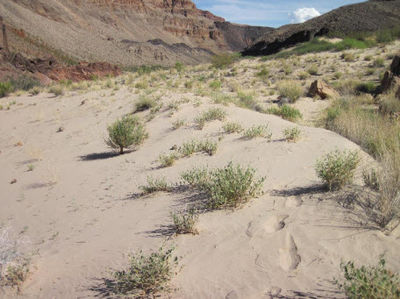
| − | Sand can potentially help preserve archaeological features by direct burial and/or by mitigating gullying and other erosion. Sand can be deposited on archaeological features or within gullies via fluvial (river) or aeolian (wind) deposition. Most archaeological sites are above the highest contemporary river stage, so aeolian deposition is the most likely mechanism for preservation and/or erosion mitigation. River-sourced sand deposition is a time-dependent process, and the outer limit of that process may extend for many years after any individual HFE. Additionally, HFEs with targeted vegetation removal could produce a net sediment surplus at some sites. [https://www.usbr.gov/uc/ | + | Sand can potentially help preserve archaeological features by direct burial and/or by mitigating gullying and other erosion. Sand can be deposited on archaeological features or within gullies via fluvial (river) or aeolian (wind) deposition. Most archaeological sites are above the highest contemporary river stage, so aeolian deposition is the most likely mechanism for preservation and/or erosion mitigation. River-sourced sand deposition is a time-dependent process, and the outer limit of that process may extend for many years after any individual HFE. Additionally, HFEs with targeted vegetation removal could produce a net sediment surplus at some sites. [https://www.usbr.gov/uc/progact/amp/twg/2017-01-26-twg-meeting/AR5_Sankey.pdf] |
|}<!-- | |}<!-- | ||
| Line 44: | Line 44: | ||
|style="color:#000;"| | |style="color:#000;"| | ||
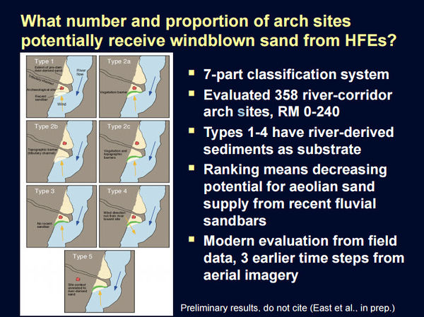
| − | [[File:AeolianClassification.jpg|center|600px | + | [[File:AeolianClassification.jpg|thumb|center|600px| [https://www.usbr.gov/uc/progact/amp/twg/2015-01-20-twg-meeting/Attach_03.pdf https://www.usbr.gov/uc/progact/amp/twg/2015-01-20-twg-meeting/Attach_03.pdf] ]] |
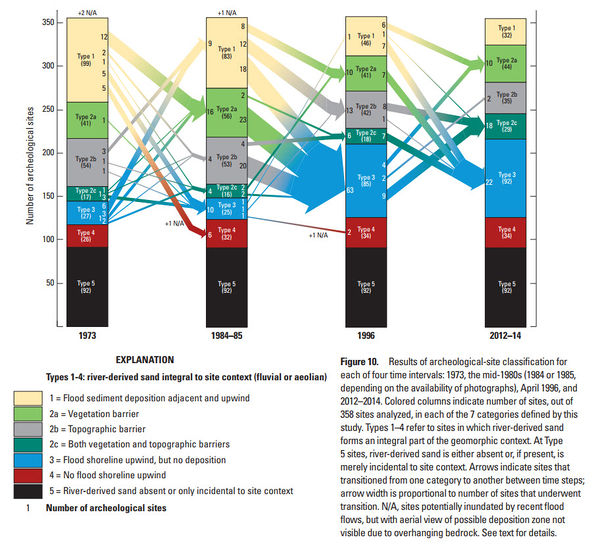
| − | [[File:AeolianSand.jpg|center|600px | + | [[File:AeolianSand.jpg|thumb|center|600px| [https://pubs.er.usgs.gov/publication/pp1825 https://pubs.er.usgs.gov/publication/pp1825] ]] |
| − | + | |- | |
| + | ! <h2 style="margin:0; background:#cedff2; font-size:120%; font-weight:bold; border:1px solid #a3b0bf; text-align:left; color:#000; padding:0.2em 0.4em;"> How many cultural sites are affected by aeolian sand transport? </h2> | ||
| + | |- | ||
| + | |style="color:#000;"| | ||
| + | |||
| + | Of 358 river-corridor arch sites (RM 0-240), 76 (21%) are adjacent and upwind of sandbars receiving HFE sand and don't have some sort of topographic barrier between the sandbar and the arch site (Type 1 and Type 2a). Of these, 44 sites (12%) are currently blocked by vegetation from receiving aeolian sand. [https://pubs.er.usgs.gov/publication/pp1825] | ||
|} | |} | ||
| Line 59: | Line 64: | ||
*[http://gcdamp.com/index.php?title=CULTURAL Cultural Resources Page] | *[http://gcdamp.com/index.php?title=CULTURAL Cultural Resources Page] | ||
*[http://gcdamp.com/index.php?title=GCDAMP_Sediment Sediment Page] | *[http://gcdamp.com/index.php?title=GCDAMP_Sediment Sediment Page] | ||
| + | *[http://gcdamp.com/index.php?title=Riparian_Vegetation Riparian Vegetation Page] | ||
|- | |- | ||
| − | ! <h2 style="margin:0; background:#cedff2; font-size:120%; font-weight:bold; border:1px solid #a3b0bf; text-align:left; color:#000; padding:0.2em 0.4em;"> | + | ! <h2 style="margin:0; background:#cedff2; font-size:120%; font-weight:bold; border:1px solid #a3b0bf; text-align:left; color:#000; padding:0.2em 0.4em;">Presentations and Papers </h2> |
|- | |- | ||
|style="color:#000;"| | |style="color:#000;"| | ||
| − | * | + | '''2023''' |
| + | *[https://doi.org/10.1016/j.geomorph.2023.109021 Caster et al. 2024, Do topographic changes tell us about variability in aeolian sediment transport and dune mobility? Analysis of monthly to decadal surface changes in a partially vegetated and biocrust covered dunefield: Geomorphology, v. 447, p. 1-16] | ||
| + | *[https://www.sciencedirect.com/science/article/pii/S0301479723008241?via%3Dihub Sankey et al. 2023. Archaeological sites in Grand Canyon National Park along the Colorado River are eroding owing to six decades of Glen Canyon Dam operations] | ||
| − | + | '''2022''' | |
| − | + | *[https://www.usbr.gov/uc/progact/amp/twg/2022-01-13-twg-meeting/20220113-AnnualReportingMeeting-ProjectDGeomorphicEffectsDamOperationsVegetationManagementArchaeologicalSites-508-UCRO.pdf Project D: Geomorphic Effects of Dam Operations and Vegetation management on Archaeological Sites ] | |
| − | + | ||
| − | + | '''2021''' | |
| + | *[https://www.usbr.gov/uc/progact/amp/amwg/2021-02-11-amwg-meeting/20210211-SandSupplyTransportDeposition-508-UCRO.pdf Sand Supply, Transport and Deposition Using Repeat Photography to Document Dam Operation Effects on Sand Supply, Aeolian Landscapes, and Terrestrial Ecology in the Colorado River Ecosystem ] | ||
| + | *[https://www.usbr.gov/uc/progact/amp/twg/2021-01-22-twg-meeting/20210122-AnnualReportingMeeting-UsingRepeatPhotographyDocumentDamOperationEffects-508-UCRO.pdf ] | ||
| + | |||
| + | '''2020''' | ||
| + | *[https://www.usbr.gov/uc/progact/amp/twg/2020-01-13-twg-meeting/20200113-AnnualReportingMeeting-GeomorphicEffectsDamOperationsVegetationManagementArchaeologicalSites-Presentation-508-UCRO.pdf Geomorphic Effects of Dam Operations and Vegetation Management for Archaeological Sites ] | ||
| + | |||
| + | '''2019''' | ||
| + | *[https://doi.org/10.3133/fs20193054 Cook et. al, 2019, Managing sand along the Colorado River to protect cultural sites downstream of Glen Canyon Dam: U.S. Geological Survey Fact Sheet 2019-3054] | ||
| + | *[https://www.usbr.gov/uc/progact/amp/twg/2019-03-14-twg-meeting/20190314-HighElevationSandCulturalSites-Presentation-508-UCRO.pdf High Elevation Sand/Cultural Sites: The response of source-bordering aeolian dunefields to the 2012-2016 High Flow Experiments of the Colorado River in Grand Canyon Presentation ] | ||
| + | |||
| + | '''2018''' | ||
| + | *[https://www.usbr.gov/uc/progact/amp/amwg/2018-08-22-amwg-meeting/Attach_14.pdf GCMRC Science Updates PPT] | ||
| + | *[https://doi.org/10.1177/0309133318795846 Kasprak et al., 2018, Quantifying and forecasting changes in the areal extent of river valley sediment in response to altered hydrology and land cover: Progress in Physical Geography: Earth and Environment] | ||
| + | *[https://doi.org/10.1016/j.geomorph.2018.07.023 Solazzo, D., Sankey, J.B., Sankey, T.Ts., Munson, S.M., 2018. Mapping and measuring aeolian sand dunes with photogrammetry and LiDAR from unmanned aerial vehicles (UAV) and multispectral satellite imagery on the Paria Plateau, AZ, USA: Geomorphology, v. 319, p. 174-185] | ||
| + | *[https://doi.org/10.1016/j.aeolia.2018.02.005 Sankey et al., 2018, The response of source-bordering aeolian dunefields to sediment-supply changes 1--Effects of wind variability and river-valley morphodynamics: Aeolian Research] | ||
| + | *[https://doi.org/10.1016/j.aeolia.2018.02.004 Sankey et al., 2018, The response of source-bordering aeolian dunefields to sediment-supply changes 2--Controlled floods of the Colorado River in Grand Canyon, Arizona, USA: Aeolian Research] | ||
'''2017''' | '''2017''' | ||
| + | *[https://doi.org/10.3133/sir20175082 East et al. 2017. Modern landscape processes affecting archaeological sites along the Colorado River corridor downstream of Glen Canyon Dam, Glen Canyon National Recreation Area, Arizona: U.S. Geological Survey Scientific Investigations Report 2017–5082, 22 p.] | ||
*[[Media:2017 Kasprak Earth Surface Processes and Landforms.pdf| Kasprak et al. 2017. Geomorphic process from topographic form: Automating the interpretation of repeat survey data in river valleys. Earth Surface Processes and Landforms.]] | *[[Media:2017 Kasprak Earth Surface Processes and Landforms.pdf| Kasprak et al. 2017. Geomorphic process from topographic form: Automating the interpretation of repeat survey data in river valleys. Earth Surface Processes and Landforms.]] | ||
*[https://www.usbr.gov/uc/rm/amp/twg/mtgs/17jan26/AR5_Sankey.pdf Fluvial-aeolian sediment connectivity during the current HFE protocol: alteration on fluvial-aeolian sediment connectivity in Grand Canyon ] | *[https://www.usbr.gov/uc/rm/amp/twg/mtgs/17jan26/AR5_Sankey.pdf Fluvial-aeolian sediment connectivity during the current HFE protocol: alteration on fluvial-aeolian sediment connectivity in Grand Canyon ] | ||
| Line 79: | Line 104: | ||
*[[Media:Collins 2016 GCArchSitesAeolian.pdf| Collins et al. 2016. Relations between rainfall–runoff-induced erosion and aeolian deposition at archaeological sites in a semi-arid dam-controlled river corridor, Earth Surf. Process. Landforms]] | *[[Media:Collins 2016 GCArchSitesAeolian.pdf| Collins et al. 2016. Relations between rainfall–runoff-induced erosion and aeolian deposition at archaeological sites in a semi-arid dam-controlled river corridor, Earth Surf. Process. Landforms]] | ||
*[https://pubs.er.usgs.gov/publication/pp1825 East et. al. 2016. Conditions and processes affecting sand resources at archeological sites in the Colorado River corridor below Glen Canyon Dam, Arizona: U.S. Geological Survey Professional Paper] | *[https://pubs.er.usgs.gov/publication/pp1825 East et. al. 2016. Conditions and processes affecting sand resources at archeological sites in the Colorado River corridor below Glen Canyon Dam, Arizona: U.S. Geological Survey Professional Paper] | ||
| − | *[https://www.usbr.gov/uc/ | + | *[https://www.usbr.gov/uc/progact/amp/twg/2016-02-26-twg-meeting/AR04_Mueller.pdf Linkages between controlled floods, eddy sandbar dynamics, and riparian vegetation along the Colorado River in Marble Canyon, Arizona, USA ] |
'''2015''' | '''2015''' | ||
| − | *[ | + | *[https://www.usbr.gov/uc/progact/amp/twg/2015-01-20-twg-meeting/Attach_03.pdf Conditions and Processes affecting sand resources at archaeological sites] |
'''2014''' | '''2014''' | ||
| − | *[ | + | *[https://www.usbr.gov/uc/progact/amp/twg/2014-01-30-twg-meeting/AR_Sankey_Gully_remote.pdf Gully annealing by Aeolian sediment: Field and remote-sensing investigation in Glen, Marble, and Grand Canyons (Sankey)] |
'''2013''' | '''2013''' | ||
| − | *[https://www.usbr.gov/uc/ | + | *[https://www.usbr.gov/uc/progact/amp/twg/2013-01-24-twg-meeting/23_Draut.pdf Aeolian Landscapes and Archaeological Sites: 2012 Progress and New Work Plan (Project J)] |
'''2012''' | '''2012''' | ||
*[https://www.gcmrc.gov/about/ka/KA%202%20-%202-1-12/AM%20Talks/Draut%201030-1145%20Aeolian%20Landscapes.pdf Aeolian Landscapes ] | *[https://www.gcmrc.gov/about/ka/KA%202%20-%202-1-12/AM%20Talks/Draut%201030-1145%20Aeolian%20Landscapes.pdf Aeolian Landscapes ] | ||
| − | ''' | + | '''2010''' |
| − | *[ | + | *[https://www.usbr.gov/uc/progact/amp/amwg/2010-02-03-amwg-meeting/Attach_25.pdf Aeolian Reworking of Sandbars from the March 2008 Glen Canyon Dam High-Flow Experiment in Grand Canyon] |
|- | |- | ||
| Line 111: | Line 136: | ||
*'''The problem:''' Landscapes downstream from Glen Canyon Dam contain archaeological resources that are affected by fluvial (river), aeolian (wind), and hillslope (gravity and rainfall-runoff) geomorphic processes. | *'''The problem:''' Landscapes downstream from Glen Canyon Dam contain archaeological resources that are affected by fluvial (river), aeolian (wind), and hillslope (gravity and rainfall-runoff) geomorphic processes. | ||
*'''The question:''' Can Colorado River sediment enhance the preservation of river corridor archaeological resources in these landscapes through aeolian sand deposition and mitigation of gully erosion? | *'''The question:''' Can Colorado River sediment enhance the preservation of river corridor archaeological resources in these landscapes through aeolian sand deposition and mitigation of gully erosion? | ||
| − | *'''The results:''' Relatively few archeological sites are now ideally situated to receive aeolian sand supply from sandbars deposited by recent controlled floods (HFEs) from Glen Canyon Dam (decreased from 98 sites in 1973 to 32 in 2012).[https://www.usbr.gov/uc/ | + | *'''The results:''' Relatively few archeological sites are now ideally situated to receive aeolian sand supply from sandbars deposited by recent controlled floods (HFEs) from Glen Canyon Dam (decreased from 98 sites in 1973 to 32 in 2012).[https://www.usbr.gov/uc/progact/amp/twg/2017-01-26-twg-meeting/AR5_Sankey.pdf] |
|} | |} | ||
Latest revision as of 14:21, 5 January 2024
|
|
Aeolian Sand TransportSand can potentially help preserve archaeological features by direct burial and/or by mitigating gullying and other erosion. Sand can be deposited on archaeological features or within gullies via fluvial (river) or aeolian (wind) deposition. Most archaeological sites are above the highest contemporary river stage, so aeolian deposition is the most likely mechanism for preservation and/or erosion mitigation. River-sourced sand deposition is a time-dependent process, and the outer limit of that process may extend for many years after any individual HFE. Additionally, HFEs with targeted vegetation removal could produce a net sediment surplus at some sites. [1] |
| --- |
--- |
--- |
|---|


